Note:
The expiration time in the watch graphic is amended if the watch is
replaced, cancelled or extended.
Note: Click for Watch Status Reports.
SEL3
URGENT - IMMEDIATE BROADCAST REQUESTED
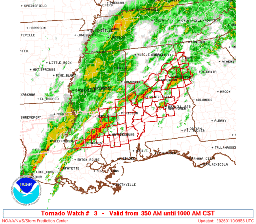
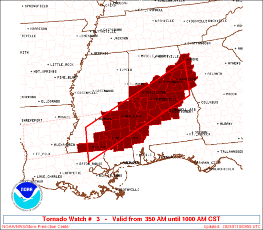
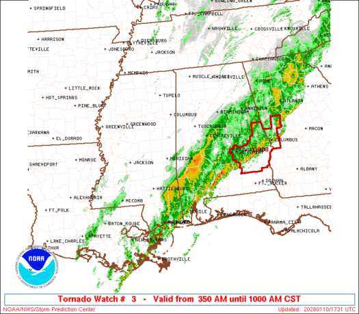
Tornado Watch Number 3
NWS Storm Prediction Center Norman OK
350 AM CST Sat Jan 10 2026
The NWS Storm Prediction Center has issued a
* Tornado Watch for portions of
Central Alabama
Northwest Georgia
Southeast Mississippi
* Effective this Saturday morning from 350 AM until 1000 AM CST.
* Primary threats include...
A few tornadoes possible
Scattered damaging wind gusts to 70 mph possible
SUMMARY...Thunderstorms will increase in coverage and intensity
through the morning as an upper trough approaches. Low-level shear
profiles will strengthen, posing a risk of a few supercells capable
of tornadoes and locally damaging wind gusts.
The tornado watch area is approximately along and 50 statute miles
north and south of a line from 10 miles northwest of Mc Comb MS to
30 miles east of Anniston AL. For a complete depiction of the watch
see the associated watch outline update (WOUS64 KWNS WOU3).
PRECAUTIONARY/PREPAREDNESS ACTIONS...
REMEMBER...A Tornado Watch means conditions are favorable for
tornadoes and severe thunderstorms in and close to the watch
area. Persons in these areas should be on the lookout for
threatening weather conditions and listen for later statements
and possible warnings.
&&
OTHER WATCH INFORMATION...CONTINUE...WW 2...
AVIATION...Tornadoes and a few severe thunderstorms with hail
surface and aloft to 0.5 inches. Extreme turbulence and surface wind
gusts to 60 knots. A few cumulonimbi with maximum tops to 500. Mean
storm motion vector 24035.
...Hart
   SEL3

   URGENT - IMMEDIATE BROADCAST REQUESTED
   Tornado Watch Number 3
   NWS Storm Prediction Center Norman OK
   350 AM CST Sat Jan 10 2026

   The NWS Storm Prediction Center has issued a

   * Tornado Watch for portions of
     Central Alabama
     Northwest Georgia
     Southeast Mississippi

   * Effective this Saturday morning from 350 AM until 1000 AM CST.

   * Primary threats include...
     A few tornadoes possible
     Scattered damaging wind gusts to 70 mph possible

   SUMMARY...Thunderstorms will increase in coverage and intensity
   through the morning as an upper trough approaches.  Low-level shear
   profiles will strengthen, posing a risk of a few supercells capable
   of tornadoes and locally damaging wind gusts.

   The tornado watch area is approximately along and 50 statute miles
   north and south of a line from 10 miles northwest of Mc Comb MS to
   30 miles east of Anniston AL. For a complete depiction of the watch
   see the associated watch outline update (WOUS64 KWNS WOU3).

   PRECAUTIONARY/PREPAREDNESS ACTIONS...

   REMEMBER...A Tornado Watch means conditions are favorable for
   tornadoes and severe thunderstorms in and close to the watch
   area. Persons in these areas should be on the lookout for
   threatening weather conditions and listen for later statements
   and possible warnings.

   &&

   OTHER WATCH INFORMATION...CONTINUE...WW 2...

   AVIATION...Tornadoes and a few severe thunderstorms with hail
   surface and aloft to 0.5 inches. Extreme turbulence and surface wind
   gusts to 60 knots. A few cumulonimbi with maximum tops to 500. Mean
   storm motion vector 24035.

   ...Hart
Note:
The Aviation Watch (SAW) product is an approximation to the watch area.
The actual watch is depicted by the shaded areas.
   SAW3
   WW 3 TORNADO AL GA MS 100950Z - 101600Z
   AXIS..50 STATUTE MILES NORTH AND SOUTH OF LINE..
   10NW MCB/MC COMB MS/ - 30E ANB/ANNISTON AL/
   ..AVIATION COORDS.. 45NM N/S /17W MCB - 32N LGC/
   HAIL SURFACE AND ALOFT..0.5 INCH. WIND GUSTS..60 KNOTS.
   MAX TOPS TO 500. MEAN STORM MOTION VECTOR 24035.

   LAT...LON 32009059 34308533 32868533 30569059

   THIS IS AN APPROXIMATION TO THE WATCH AREA.  FOR A
   COMPLETE DEPICTION OF THE WATCH SEE WOUS64 KWNS
   FOR WOU3.
Watch 3 Status Report Messages:
STATUS REPORT #4 ON WW 3

VALID 101545Z - 101640Z

SEVERE WEATHER THREAT CONTINUES RIGHT OF A LINE FROM 20 SE SEM TO
35 SSW ANB TO 20 SSE RMG.

FOR ADDITIONAL INFORMATION SEE MESOSCALE DISCUSSION 20

..WEINMAN..01/10/26

ATTN...WFO...BMX...MOB...FFC...LIX...JAN...

&&

STATUS REPORT FOR WT 3

SEVERE WEATHER THREAT CONTINUES FOR THE FOLLOWING AREAS

ALC005-011-017-025-027-051-081-085-087-101-109-111-113-123-129-
131-101640-

AL
.    ALABAMA COUNTIES INCLUDED ARE

BARBOUR 	     BULLOCK		 CHAMBERS
CLARKE		     CLAY		 ELMORE
LEE		     LOWNDES		 MACON
MONTGOMERY	     PIKE		 RANDOLPH
RUSSELL 	     TALLAPOOSA 	 WASHINGTON
WILCOX
$$


GAC045-149-101640-

GA
.    GEORGIA COUNTIES INCLUDED ARE

CARROLL 	     HEARD
$$


MSC041-111-101640-

MS
.    MISSISSIPPI COUNTIES INCLUDED ARE

GREENE		     PERRY
$$


THE WATCH STATUS MESSAGE IS FOR GUIDANCE PURPOSES ONLY.  PLEASE
REFER TO WATCH COUNTY NOTIFICATION STATEMENTS FOR OFFICIAL
INFORMATION ON COUNTIES...INDEPENDENT CITIES AND MARINE ZONES
CLEARED FROM SEVERE THUNDERSTORM AND TORNADO WATCHES.
$$

STATUS REPORT #3 ON WW 3

VALID 101440Z - 101540Z

SEVERE WEATHER THREAT CONTINUES RIGHT OF A LINE FROM 40 SSW PIB
TO 10 SE PIB TO 30 WSW SEM TO 35 N SEM TO 10 NNW RMG.

FOR ADDITIONAL INFORMATION SEE MESOSCALE DISCUSSION 19

..WEINMAN..01/10/26

ATTN...WFO...BMX...MOB...FFC...LIX...JAN...

&&

STATUS REPORT FOR WT 3

SEVERE WEATHER THREAT CONTINUES FOR THE FOLLOWING AREAS

ALC001-015-019-021-025-027-029-037-047-051-085-101-111-121-123-
129-131-101540-

AL
.    ALABAMA COUNTIES INCLUDED ARE

AUTAUGA 	     CALHOUN		 CHEROKEE
CHILTON 	     CLARKE		 CLAY
CLEBURNE	     COOSA		 DALLAS
ELMORE		     LOWNDES		 MONTGOMERY
RANDOLPH	     TALLADEGA		 TALLAPOOSA
WASHINGTON	     WILCOX
$$


GAC045-055-115-143-149-233-101540-

GA
.    GEORGIA COUNTIES INCLUDED ARE

CARROLL 	     CHATTOOGA		 FLOYD
HARALSON	     HEARD		 POLK
$$


MSC035-041-111-101540-

MS
.    MISSISSIPPI COUNTIES INCLUDED ARE

FORREST 	     GREENE		 PERRY
$$


THE WATCH STATUS MESSAGE IS FOR GUIDANCE PURPOSES ONLY.  PLEASE
REFER TO WATCH COUNTY NOTIFICATION STATEMENTS FOR OFFICIAL
INFORMATION ON COUNTIES...INDEPENDENT CITIES AND MARINE ZONES
CLEARED FROM SEVERE THUNDERSTORM AND TORNADO WATCHES.
$$

STATUS REPORT #2 ON WW 3

VALID 101330Z - 101440Z

SEVERE WEATHER THREAT CONTINUES RIGHT OF A LINE FROM 40 N ASD TO
30 WSW PIB TO 35 ESE MEI TO 40 SSW TCL TO 20 SW BHM TO 15 WSW GAD.

..KERR..01/10/26

ATTN...WFO...BMX...MOB...FFC...LIX...JAN...

&&

STATUS REPORT FOR WT 3

SEVERE WEATHER THREAT CONTINUES FOR THE FOLLOWING AREAS

ALC001-007-015-019-021-023-025-027-029-037-047-051-055-065-073-
085-091-101-105-111-115-117-121-123-129-131-101440-

AL
.    ALABAMA COUNTIES INCLUDED ARE

AUTAUGA 	     BIBB		 CALHOUN
CHEROKEE	     CHILTON		 CHOCTAW
CLARKE		     CLAY		 CLEBURNE
COOSA		     DALLAS		 ELMORE
ETOWAH		     HALE		 JEFFERSON
LOWNDES 	     MARENGO		 MONTGOMERY
PERRY		     RANDOLPH		 ST. CLAIR
SHELBY		     TALLADEGA		 TALLAPOOSA
WASHINGTON	     WILCOX
$$


GAC045-055-115-143-149-233-101440-

GA
.    GEORGIA COUNTIES INCLUDED ARE

CARROLL 	     CHATTOOGA		 FLOYD
HARALSON	     HEARD		 POLK
$$


MSC035-041-073-111-153-101440-

MS
.    MISSISSIPPI COUNTIES INCLUDED ARE

FORREST 	     GREENE		 LAMAR
PERRY		     WAYNE
$$


THE WATCH STATUS MESSAGE IS FOR GUIDANCE PURPOSES ONLY.  PLEASE
REFER TO WATCH COUNTY NOTIFICATION STATEMENTS FOR OFFICIAL
INFORMATION ON COUNTIES...INDEPENDENT CITIES AND MARINE ZONES
CLEARED FROM SEVERE THUNDERSTORM AND TORNADO WATCHES.
$$

STATUS REPORT #1 ON WW 3

VALID 101230Z - 101340Z

SEVERE WEATHER THREAT CONTINUES RIGHT OF A LINE FROM 15 SSW MCB
TO 5 E MEI TO 10 S TCL TO 25 NE TCL.

..KERR..01/10/26

ATTN...WFO...BMX...MOB...FFC...LIX...JAN...

&&

STATUS REPORT FOR WT 3

SEVERE WEATHER THREAT CONTINUES FOR THE FOLLOWING AREAS

ALC001-007-015-019-021-023-025-027-029-037-047-051-055-063-065-
073-085-091-101-105-111-115-117-119-121-123-125-129-131-
101340-

AL
.    ALABAMA COUNTIES INCLUDED ARE

AUTAUGA 	     BIBB		 CALHOUN
CHEROKEE	     CHILTON		 CHOCTAW
CLARKE		     CLAY		 CLEBURNE
COOSA		     DALLAS		 ELMORE
ETOWAH		     GREENE		 HALE
JEFFERSON	     LOWNDES		 MARENGO
MONTGOMERY	     PERRY		 RANDOLPH
ST. CLAIR	     SHELBY		 SUMTER
TALLADEGA	     TALLAPOOSA 	 TUSCALOOSA
WASHINGTON	     WILCOX
$$


GAC045-055-115-143-149-233-101340-

GA
.    GEORGIA COUNTIES INCLUDED ARE

CARROLL 	     CHATTOOGA		 FLOYD
HARALSON	     HEARD		 POLK
$$


MSC023-031-035-041-061-065-067-073-075-091-111-147-153-101340-

MS
.    MISSISSIPPI COUNTIES INCLUDED ARE

CLARKE		     COVINGTON		 FORREST
GREENE		     JASPER		 JEFFERSON DAVIS
JONES		     LAMAR		 LAUDERDALE
MARION		     PERRY		 WALTHALL
WAYNE
$$


THE WATCH STATUS MESSAGE IS FOR GUIDANCE PURPOSES ONLY.  PLEASE
REFER TO WATCH COUNTY NOTIFICATION STATEMENTS FOR OFFICIAL
INFORMATION ON COUNTIES...INDEPENDENT CITIES AND MARINE ZONES
CLEARED FROM SEVERE THUNDERSTORM AND TORNADO WATCHES.
$$
Note:
Click for Complete Product Text.
Tornadoes
| Probability of 2 or more tornadoes |
Mod (50%)
|
| Probability of 1 or more strong (EF2-EF5) tornadoes |
Low (20%)
|
Wind
| Probability of 10 or more severe wind events |
Mod (40%)
|
| Probability of 1 or more wind events > 65 knots |
Low (20%)
|
Hail
| Probability of 10 or more severe hail events |
Low (<5%)
|
| Probability of 1 or more hailstones > 2 inches |
Low (<5%)
|
Combined Severe Hail/Wind
| Probability of 6 or more combined severe hail/wind events |
Mod (50%)
|
For each watch, probabilities for particular events inside the watch
(listed above in each table) are determined by the issuing forecaster.
The “Low” category contains probability values ranging from less than 2%
to 20% (EF2-EF5 tornadoes), less than 5% to 20% (all other probabilities),
“Moderate” from 30% to 60%, and “High” from 70% to greater than 95%.
High values are bolded and lighter in color to provide awareness of
an increased threat for a particular event.
Source link

