Note:
The expiration time in the watch graphic is amended if the watch is
replaced, cancelled or extended.
Note: Click for Watch Status Reports.
SEL2
URGENT - IMMEDIATE BROADCAST REQUESTED
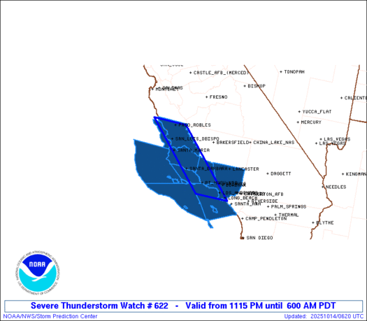
Severe Thunderstorm Watch Number 622
NWS Storm Prediction Center Norman OK
1115 PM PDT Mon Oct 13 2025
The NWS Storm Prediction Center has issued a
* Severe Thunderstorm Watch for portions of
Southern California
Coastal Waters
* Effective this Monday night and Tuesday morning from 1115 PM
until 600 AM PDT.
* Primary threats include...
Isolated damaging wind gusts to 70 mph possible
A tornado or two possible
SUMMARY...A line of low-topped convection will move
east-southeastward through the early morning hours while posing a
threat for mainly occasional strong to damaging winds. A brief
tornado or two may also occur.
The severe thunderstorm watch area is approximately along and 35
statute miles east and west of a line from 15 miles west northwest
of Paso Robles CA to 20 miles southwest of Los Angeles CA. For a
complete depiction of the watch see the associated watch outline
update (WOUS64 KWNS WOU2).
PRECAUTIONARY/PREPAREDNESS ACTIONS...
REMEMBER...A Severe Thunderstorm Watch means conditions are
favorable for severe thunderstorms in and close to the watch area.
Persons in these areas should be on the lookout for threatening
weather conditions and listen for later statements and possible
warnings. Severe thunderstorms can and occasionally do produce
tornadoes.
&&
AVIATION...A few severe thunderstorms with hail surface and aloft to
0 inches. Extreme turbulence and surface wind gusts to 60 knots. A
few cumulonimbi with maximum tops to 250. Mean storm motion vector
29030.
...Gleason
Note:
The Aviation Watch (SAW) product is an approximation to the watch area.
The actual watch is depicted by the shaded areas.
   SAW2
   WW 622 SEVERE TSTM CA CW 140615Z - 141300Z
   AXIS..35 STATUTE MILES EAST AND WEST OF LINE..
   15WNW PRB/PASO ROBLES CA/ - 20SW LAX/LOS ANGELES CA/
   ..AVIATION COORDS.. 30NM E/W /65SSE SNS - 15SW LAX/
   WIND GUSTS..60 KNOTS.
   MAX TOPS TO 250.MEAN STORM MOTION VECTOR 29030.

   LAT...LON 35752025 33741804 33741926 35752150

   THIS IS AN APPROXIMATION TO THE WATCH AREA.  FOR A
   COMPLETE DEPICTION OF THE WATCH SEE WOUS64 KWNS
   FOR WOU2.
Watch 622 Status Report Messages:
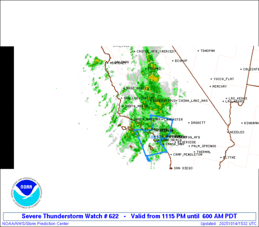
STATUS REPORT #4 ON WW 622

VALID 141245Z - 141340Z

SEVERE WEATHER THREAT CONTINUES RIGHT OF A LINE FROM 25 SSE SBA
TO 20 NE SBA TO 35 SSW BFL.

FOR ADDITIONAL INFORMATION SEE MESOSCALE DISCUSSION 2146

..SQUITIERI..10/14/25

ATTN...WFO...LOX...

&&

STATUS REPORT FOR WS 622

SEVERE WEATHER THREAT CONTINUES FOR THE FOLLOWING AREAS

CAC037-111-141340-

CA
.    CALIFORNIA COUNTIES INCLUDED ARE

LOS ANGELES	     VENTURA
$$


PZZ655-676-141340-

CW

.    ADJACENT COASTAL WATERS INCLUDED ARE

INNER WATERS FROM POINT MUGU TO SAN MATEO PT. CA INCLUDING SANTA
CATALINA AND ANACAPA ISLANDS

OUTER WATERS FROM SANTA CRUZ ISLAND TO SAN CLEMENTE ISLAND TO 60
NM OFFSHORE INCLUDING SAN NICOLAS AND SANTA BARBARA ISLANDS

$$
THE WATCH STATUS MESSAGE IS FOR GUIDANCE PURPOSES ONLY.  PLEASE
REFER TO WATCH COUNTY NOTIFICATION STATEMENTS FOR OFFICIAL
INFORMATION ON COUNTIES...INDEPENDENT CITIES AND MARINE ZONES
CLEARED FROM SEVERE THUNDERSTORM AND TORNADO WATCHES.
$$

STATUS REPORT #3 ON WW 622

VALID 141115Z - 141240Z

SEVERE WEATHER THREAT CONTINUES RIGHT OF A LINE FROM 25 SE VBG TO
30 WSW BFL.

..SQUITIERI..10/14/25

ATTN...WFO...LOX...

&&

STATUS REPORT FOR WS 622

SEVERE WEATHER THREAT CONTINUES FOR THE FOLLOWING AREAS

CAC037-111-141240-

CA
.    CALIFORNIA COUNTIES INCLUDED ARE

LOS ANGELES	     VENTURA
$$


PZZ655-676-141240-

CW

.    ADJACENT COASTAL WATERS INCLUDED ARE

INNER WATERS FROM POINT MUGU TO SAN MATEO PT. CA INCLUDING SANTA
CATALINA AND ANACAPA ISLANDS

OUTER WATERS FROM SANTA CRUZ ISLAND TO SAN CLEMENTE ISLAND TO 60
NM OFFSHORE INCLUDING SAN NICOLAS AND SANTA BARBARA ISLANDS

$$
THE WATCH STATUS MESSAGE IS FOR GUIDANCE PURPOSES ONLY.  PLEASE
REFER TO WATCH COUNTY NOTIFICATION STATEMENTS FOR OFFICIAL
INFORMATION ON COUNTIES...INDEPENDENT CITIES AND MARINE ZONES
CLEARED FROM SEVERE THUNDERSTORM AND TORNADO WATCHES.
$$

STATUS REPORT #2 ON WW 622

VALID 140915Z - 141040Z

SEVERE WEATHER THREAT CONTINUES RIGHT OF A LINE FROM 5 SE VBG TO
35 E PRB.

..SQUITIERI..10/14/25

ATTN...WFO...LOX...

&&

STATUS REPORT FOR WS 622

SEVERE WEATHER THREAT CONTINUES FOR THE FOLLOWING AREAS

CAC037-083-111-141040-

CA
.    CALIFORNIA COUNTIES INCLUDED ARE

LOS ANGELES	     SANTA BARBARA	 VENTURA
$$


PZZ650-655-673-676-141040-

CW

.    ADJACENT COASTAL WATERS INCLUDED ARE

EAST SANTA BARBARA CHANNEL FROM PT. CONCEPTION TO PT. MUGU CA
INCLUDING SANTA CRUZ ISLAND

INNER WATERS FROM POINT MUGU TO SAN MATEO PT. CA INCLUDING SANTA
CATALINA AND ANACAPA ISLANDS

WATERS FROM PT. SAL TO SANTA CRUZ ISLAND CA AND WESTWARD 60 NM
INCLUDING SAN MIGUEL AND SANTA ROSA ISLANDS

OUTER WATERS FROM SANTA CRUZ ISLAND TO SAN CLEMENTE ISLAND TO 60
NM OFFSHORE INCLUDING SAN NICOLAS AND SANTA BARBARA ISLANDS

$$
THE WATCH STATUS MESSAGE IS FOR GUIDANCE PURPOSES ONLY.  PLEASE
REFER TO WATCH COUNTY NOTIFICATION STATEMENTS FOR OFFICIAL
INFORMATION ON COUNTIES...INDEPENDENT CITIES AND MARINE ZONES
CLEARED FROM SEVERE THUNDERSTORM AND TORNADO WATCHES.
$$

STATUS REPORT #1 ON WW 622

VALID 140755Z - 140840Z

SEVERE WEATHER THREAT CONTINUES RIGHT OF A LINE FROM 15 WNW SMX
TO 25 ENE PRB.

..SQUITIERI..10/14/25

ATTN...WFO...LOX...

&&

STATUS REPORT FOR WS 622

SEVERE WEATHER THREAT CONTINUES FOR THE FOLLOWING AREAS

CAC037-079-083-111-140840-

CA
.    CALIFORNIA COUNTIES INCLUDED ARE

LOS ANGELES	     SAN LUIS OBISPO	 SANTA BARBARA
VENTURA
$$


PZZ650-655-673-676-140840-

CW

.    ADJACENT COASTAL WATERS INCLUDED ARE

EAST SANTA BARBARA CHANNEL FROM PT. CONCEPTION TO PT. MUGU CA
INCLUDING SANTA CRUZ ISLAND

INNER WATERS FROM POINT MUGU TO SAN MATEO PT. CA INCLUDING SANTA
CATALINA AND ANACAPA ISLANDS

WATERS FROM PT. SAL TO SANTA CRUZ ISLAND CA AND WESTWARD 60 NM
INCLUDING SAN MIGUEL AND SANTA ROSA ISLANDS

OUTER WATERS FROM SANTA CRUZ ISLAND TO SAN CLEMENTE ISLAND TO 60
NM OFFSHORE INCLUDING SAN NICOLAS AND SANTA BARBARA ISLANDS

$$
THE WATCH STATUS MESSAGE IS FOR GUIDANCE PURPOSES ONLY.  PLEASE
REFER TO WATCH COUNTY NOTIFICATION STATEMENTS FOR OFFICIAL
INFORMATION ON COUNTIES...INDEPENDENT CITIES AND MARINE ZONES
CLEARED FROM SEVERE THUNDERSTORM AND TORNADO WATCHES.
$$
Note:
Click for Complete Product Text.
Tornadoes
| Probability of 2 or more tornadoes |
Low (20%)
|
| Probability of 1 or more strong (EF2-EF5) tornadoes |
Low (
|
Wind
| Probability of 10 or more severe wind events |
Mod (30%)
|
| Probability of 1 or more wind events > 65 knots |
Low (10%)
|
Hail
| Probability of 10 or more severe hail events |
Low (
|
| Probability of 1 or more hailstones > 2 inches |
Low (
|
Combined Severe Hail/Wind
| Probability of 6 or more combined severe hail/wind events |
Mod (50%)
|
For each watch, probabilities for particular events inside the watch
(listed above in each table) are determined by the issuing forecaster.
The “Low” category contains probability values ranging from less than 2%
to 20% (EF2-EF5 tornadoes), less than 5% to 20% (all other probabilities),
“Moderate” from 30% to 60%, and “High” from 70% to greater than 95%.
High values are bolded and lighter in color to provide awareness of
an increased threat for a particular event.
Source link

