|
|
| Mesoscale Discussion 88 | |
|
|
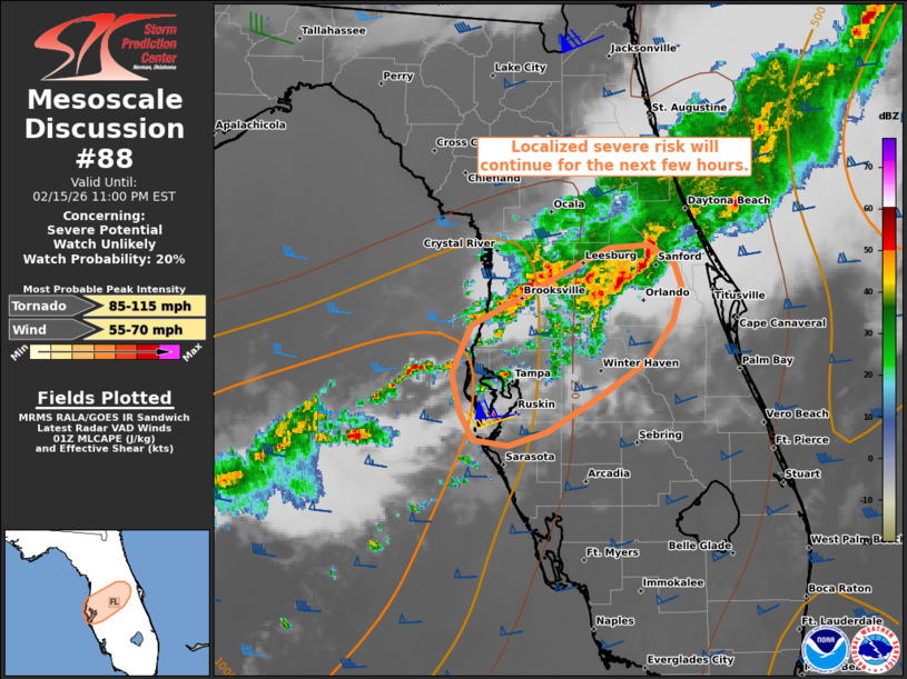
   Mesoscale Discussion 0088
   NWS Storm Prediction Center Norman OK
   0734 PM CST Sun Feb 15 2026

   Areas affected...Parts of north-central Florida

   Concerning...Severe potential...Watch unlikely

   Valid 160134Z - 160400Z

   Probability of Watch Issuance...20 percent

   SUMMARY...A localized risk of strong/damaging gusts and perhaps a
   brief tornado will continue for the next few hours across parts of
   north-central Florida.

   DISCUSSION...Clusters of mainly disorganized thunderstorms continue
   spreading/developing east-southeastward across north-central FL
   within a zone of low-level confluence and weak positive theta-e
   advection. Weak pre-convective buoyancy may continue to limit
   updraft intensity, though a narrow plume of middle/upper 60s
   dewpoints is contributing to 500-1000 J/kg MLCAPE closer to the
   coast. Despite the weak buoyancy, the TBW 00Z sounding and VWP are
   sampling strong low/deep-layer shear -- aided by a 40-50-kt
   southwesterly low-level jet and 60-70-kt midlevel flow. Enhanced
   low-level hodograph curvature (around 350 m2/s2 0-1 km SRH) may
   favor transient circulations embedded within the clusters of storms
   as they continue east-southeastward, and locally damaging gusts
   and/or a brief tornado cannot be entirely ruled out for the next few
   hours. Any severe risk is expected to remain too limited for a
   watch.

   ..Weinman/Hart.. 02/16/2026

   ...Please see www.spc.noaa.gov for graphic product...

   ATTN...WFO...MLB...TBW...

   LAT...LON   28938133 28808112 28648106 28378112 28098133 27848171
               27568217 27478249 27508277 27718289 28008295 28358279
               28928165 28938133

   MOST PROBABLE PEAK TORNADO INTENSITY...85-115 MPH
   MOST PROBABLE PEAK WIND GUST...55-70 MPH
|
|
|
Top/All Mesoscale Discussions/Forecast Products/Home |
|