|
|
| Mesoscale Discussion 86 | |
|
|
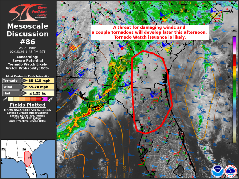
   Mesoscale Discussion 0086
   NWS Storm Prediction Center Norman OK
   1109 AM CST Sun Feb 15 2026

   Areas affected...Parts of south GA into north FL

   Concerning...Severe potential...Tornado Watch likely

   Valid 151709Z - 151845Z

   Probability of Watch Issuance...80 percent

   SUMMARY...A threat for damaging winds and a couple tornadoes will
   develop later this afternoon. Tornado Watch issuance is likely.

   DISCUSSION...A QLCS has continued to become better organized late
   this morning from southwest GA into the FL Panhandle, with some
   earlier reported wind damage and occasional embedded circulations
   noted on radar. The downstream environment into southeast GA and the
   northern FL Peninsula is currently rather dry and stable. However,
   continued diurnal heating will result in temperatures warming
   through the 70s F, while continued low-level moisture transport will
   allow dewpoints to rise into the 60s F. MLCAPE is expected to
   increase into the 500-1000 J/kg range (locally greater where
   stronger heating occurs) ahead of the ongoing QLCS, supporting
   maintenance and potential intensification of this system as it moves
   eastward.

   While some veering of low-level flow is expected with time, strong
   deep-layer flow will continue to result in favorable wind profiles,
   with effective SRH of 200-300 m2/s2 expected to persist ahead of the
   QLCS. Persist bowing segments and embedded mesocyclones will pose a
   threat of damaging wind and perhaps a couple of tornadoes. A couple
   semi-discrete cells may eventually develop along the southern
   periphery of the QLCS, which could pose some threat of all severe
   hazards (including hail), though this scenario is more uncertain.

   As ongoing convection begins to approach the eastern portion of WW
   8, downstream Tornado Watch issuance into parts of southeast GA and
   north FL is expected this afternoon.

   ..Dean/Gleason.. 02/15/2026

   ...Please see www.spc.noaa.gov for graphic product...

   ATTN...WFO...CHS...MLB...TBW...JAX...FFC...TAE...

   LAT...LON   29208305 30898320 31918319 32238264 32128209 31918160
               31288137 29948116 29828112 28938170 28738200 28598250
               28718290 29208305

   MOST PROBABLE PEAK TORNADO INTENSITY...85-115 MPH
   MOST PROBABLE PEAK WIND GUST...55-70 MPH
   MOST PROBABLE PEAK HAIL SIZE...UP TO 1.25 IN
|
|
|
Top/All Mesoscale Discussions/Forecast Products/Home |
|