|
|
| Mesoscale Discussion 82 | |
|
|
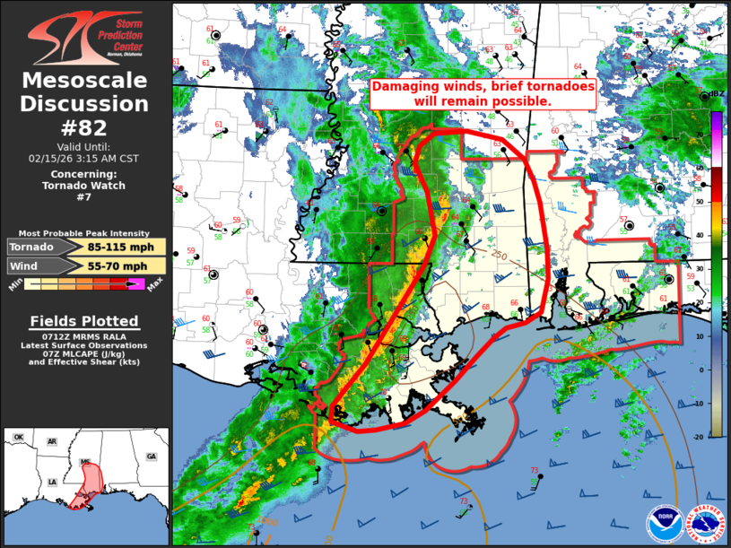
Mesoscale Discussion 0082 NWS Storm Prediction Center Norman OK 0115 AM CST Sun Feb 15 2026 Areas affected...Southern Mississippi...far southeast Louisiana and far southwest Alabama Concerning...Tornado Watch 7... Valid 150715Z - 150915Z The severe weather threat for Tornado Watch 7 continues. SUMMARY...The potential for severe gusts and brief embedded circulations is expected to continue across portions of the lower Mississippi River Valley and into far southwest Alabama over the next several hours. DISCUSSION...A well-organized QLCS continues to progress eastward across the lower MS River Valley per regional radar mosaics. KDGX imagery has sampled at least two tornadic debris signatures within the past hour on the northern flank of a bowing segment of the line where 0-1 km SRH is on the order of 400 m2/s2 per KDGX VWP observations. However, this section of the line is moving into a drier, less buoyant airmass, and lightning activity has been decreasing within the past 20-30 minutes. While brief circulations will remain possible in the near-term (next hour or so), a gradual weakening of the line is anticipated roughly along and north of Highway 84 in southern MS/southwest AL. Further south, more backed southerly winds imply slightly weaker low-level shear, but a recent 06 UTC sounding from LIX sampled around 280 m2/s2 effective SRH within a sufficiently buoyant air mass preceding the line. This environment will continue to support organized convection with the potential for strong/severe wind gusts and embedded mesovortices - especially where more meridional segments can become established within the line. Coastal surface observations show mid-60 dewpoints spreading as far east as the MS/AL border, suggesting that the downstream environment is favorable for maintaining the QLCS for several more hours along and just north of the coastline. ..Moore.. 02/15/2026 ...Please see www.spc.noaa.gov for graphic product... ATTN...WFO...MOB...JAN...LIX... LAT...LON 29339104 29839059 30968982 31338968 31838979 32168995 32378989 32528970 32548925 32448876 32228846 31958832 31708825 31168816 30818815 30428824 30308846 30258872 30138887 29928912 29648940 29298980 29139007 29069045 29049069 29159104 29339104 MOST PROBABLE PEAK TORNADO INTENSITY...85-115 MPH MOST PROBABLE PEAK WIND GUST...55-70 MPH |
|
|
Top/All Mesoscale Discussions/Forecast Products/Home |
|