|
|
| Mesoscale Discussion 78 | |
| Next MD > | |
|
|
Mesoscale Discussion 0078
NWS Storm Prediction Center Norman OK
0602 PM CST Sat Feb 14 2026
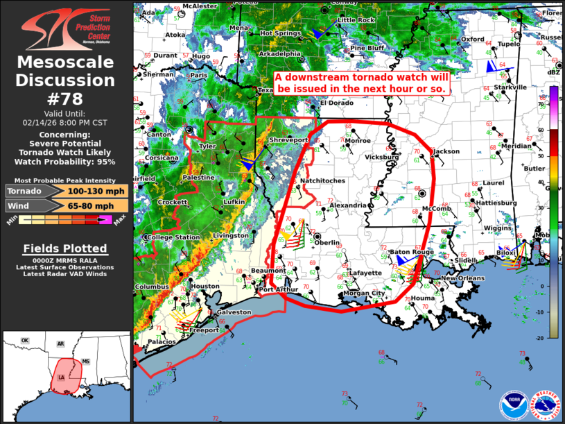
Areas affected...Much of Louisiana into southwestern Mississippi
Concerning...Severe potential...Tornado Watch likely
Valid 150002Z - 150200Z
Probability of Watch Issuance...95 percent
SUMMARY...The severe threat will continue spreading eastward across
Louisiana into southwestern Mississippi tonight. The primary concern
will be a few tornadoes and damaging wind gusts. A downstream
tornado watch will be issued in the next hour or so.
DISCUSSION...An increasingly organized north/south-oriented squall
line is tracking eastward along a surface cold front at around 30 kt
in far eastern TX. Damaging gusts have been a concern with this
activity -- given the primarily linear mode, though transient
circulations have also posed a risk of brief tornadoes.
Ahead of the line, the SHV and POE VWPs already show a large
clockwise-curved hodograph (upwards of 300-350 m2/s2 0-1 km SRH). As
a robust midlevel trough continues eastward, this wind profile will
be maintained over the warm sector, with additional strengthening of
the low-level jet possible. While buoyancy will remain somewhat
limited with eastward extent, the favorable wind profile,
strengthening low-level mass response, and moist pre-convective air
mass will continue to favor an organized line with embedded
mesovorticies and supercell structures. As a result, damaging wind
gusts and a few tornadoes will be the primary concerns (and a strong
tornado cannot be ruled out). A downstream tornado watch will be
issued in the next hour or so.
..Weinman/Hart.. 02/15/2026
...Please see www.spc.noaa.gov for graphic product...
ATTN...WFO...JAN...LIX...LCH...SHV...
LAT...LON 30669359 32039315 32709283 32959245 32969193 32909114
32709055 32379018 31879015 31079025 29949062 29619100
29449215 29539292 29689332 29959364 30669359
MOST PROBABLE PEAK TORNADO INTENSITY...100-130 MPH
MOST PROBABLE PEAK WIND GUST...65-80 MPH
|
|
|
Top/All Mesoscale Discussions/Forecast Products/Home |
|