|
|
| Mesoscale Discussion 72 | |
|
|
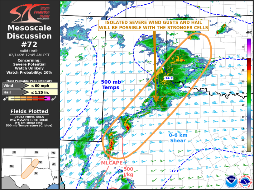
   Mesoscale Discussion 0072
   NWS Storm Prediction Center Norman OK
   1011 PM CST Fri Feb 13 2026

   Areas affected...West and Northwest Texas...Western Oklahoma

   Concerning...Severe potential...Watch unlikely

   Valid 140411Z - 140645Z

   Probability of Watch Issuance...20 percent

   SUMMARY...Isolated severe wind gusts and hail will be possible over
   the next few hours across parts of west and northwest Texas into
   western Oklahoma.

   DISCUSSION...The latest mosaic radar imagery shows a
   southwest-to-northeast corridor of scattered thunderstorm
   development from west Texas into western Oklahoma. This activity is
   being supported by warm advection and by large-scale ascent within
   southwesterly mid-level flow. The storms are located near an axis of
   weak instability, where the RAP has SBCAPE generally less than 500
   J/kg. The RAP is also analyzing a 70 to 80 knot mid-level jet from
   southeast New Mexico into southwest Oklahoma. This feature is
   creating strong deep-layer shear over most of the southern High
   Plains, which will continue to be favorable for a marginal severe
   threat late this evening into the early overnight period. Isolated
   severe wind gusts and hail will be the primary threats.

   ..Broyles/Hart.. 02/14/2026

   ...Please see www.spc.noaa.gov for graphic product...

   ATTN...WFO...OUN...SJT...LUB...AMA...MAF...

   LAT...LON   35629966 36219892 36359857 36279816 36109794 35699782
               35179794 34269870 33329961 31870121 31580159 31390194
               31350239 31500280 31750296 32200298 32880240 34740053
               35629966

   MOST PROBABLE PEAK WIND GUST...UP TO 60 MPH
   MOST PROBABLE PEAK HAIL SIZE...UP TO 1.25 IN
|
|
|
Top/All Mesoscale Discussions/Forecast Products/Home |
|