| Mesoscale Discussion 66 | |
| < Previous MD | |
|
|
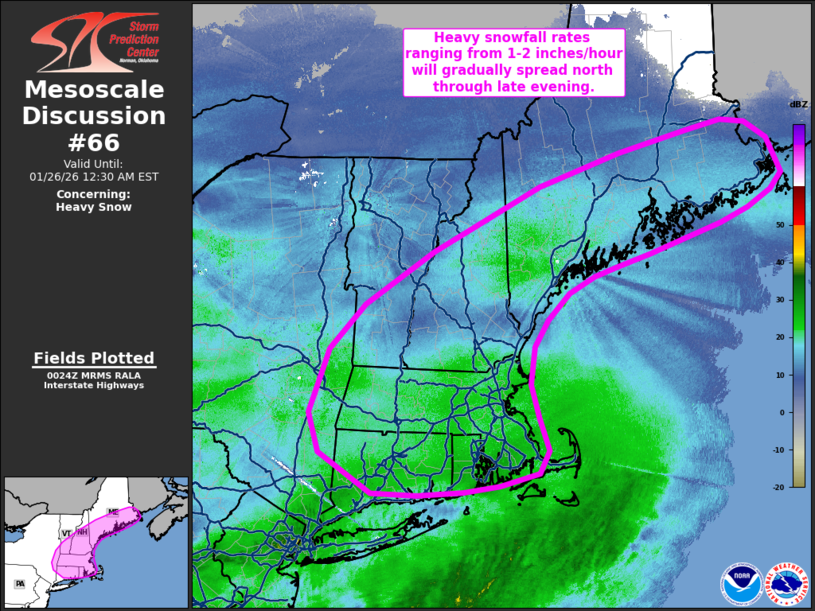
   Mesoscale Discussion 0066
   NWS Storm Prediction Center Norman OK
   0626 PM CST Sun Jan 25 2026

   Areas affected...New England into southern and eastern Maine

   Concerning...Heavy snow

   Valid 260026Z - 260530Z

   SUMMARY...Heavy snowfall rates on the order of 1-2 inches/hour are
   expected to linger in portions of New England and gradually spread
   north into southern and eastern Maine through the late evening
   hours.

   DISCUSSION...Latest surface observations and web cams continue to
   depict widespread heavy snowfall across the New England region with
   visibility reductions down to 1/4 mile or less. This activity
   continues to be driven primarily by intense warm air advection
   through a deep layer (approximately from the surface through 4 km
   AGL based on hodograph curvature in regional VWPs). Latest RAP
   mesoanalyses also depict strengthening frontogenesis within the warm
   frontal zone, which is enhancing mesoscale ascent across the region.
   This frontal zone is expected to gradually shift northward over the
   next several hours, resulting in a slow northward spread of
   precipitation. Additionally, recent 00z ALB and GYX soundings both
   sampled deep saturated profiles with several layers within the
   dendritic growth zone. These RAOBs align well with recent forecast
   soundings for the greater New England region and will continue to
   promote efficient snowfall production. Snowfall rates on the order
   of 1-2 inches/hour will likely continue for at least a few more
   hours across portions of New England, and an uptick in snowfall
   intensity is expected across southern to eastern ME - especially
   along the ME coastline where heavy snow banding appears most
   probable based on QPF output from recent CAM solutions.

   ..Moore.. 01/26/2026

   ...Please see www.spc.noaa.gov for graphic product...

   ATTN...WFO...CAR...GYX...BOX...BTV...OKX...ALY...

   LAT...LON   42197052 41837036 41597050 41447109 41387161 41347230
               41357298 41807375 42237391 42927362 43417310 43997209
               44707050 45066929 45306827 45416773 45386737 45196704
               44826683 44636699 44456734 44296777 44136827 43976884
               43826934 43726968 43557006 43267037 42967057 42557064
               42197052
|
|
|
Top/All Mesoscale Discussions/Forecast Products/Home |
|