| Mesoscale Discussion 65 | |
| < Previous MD Next MD > | |
|
|
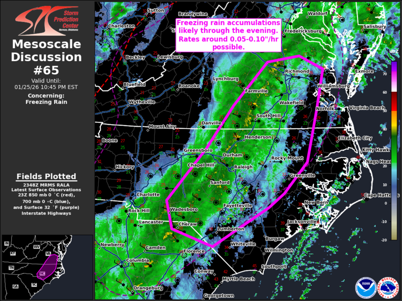
   Mesoscale Discussion 0065
   NWS Storm Prediction Center Norman OK
   0550 PM CST Sun Jan 25 2026

   Areas affected...southern Virginia...central North Carolina

   Concerning...Freezing rain

   Valid 252350Z - 260345Z

   SUMMARY...Freezing rain accumulations likely this evening. Rates
   around 0.05-0.10"/hr will be possible.

   DISCUSSION...Freezing rain reports continue across portions of
   central north Carolina into southern Virginia. The main heavy
   precipitation is now shifting just west of the Charlotte Metro into
   the Richmond Metro. Rates within this line across central North
   Carolina into southern Virginia have been around 0.05-0.10"/hr.
   These rates will likely continue within the heavier band of
   precipitation over the next several hours. A few reports of sleet
   are also noted at times. RAP forecast sounding data suggests there
   is a pronounced warm nose atop a rather shallow area sub-freezing
   air near the surface. The primary precipitation type will likely
   remain freezing rain with this profile, but a few areas of sleet
   mixing in will be possible especially further north into Virginia
   where temperatures are much cooler.

   ..Thornton.. 01/25/2026

   ...Please see www.spc.noaa.gov for graphic product...

   ATTN...WFO...AKQ...MHX...RAH...ILM...RNK...CAE...

   LAT...LON   36197924 36977862 37787783 37897709 37647655 36897671
               35927693 35337747 35087781 34347909 34678000 35198014
               36197924
|
|
|
Top/All Mesoscale Discussions/Forecast Products/Home |
|