| Mesoscale Discussion 6 | |
| < Previous MD | |

|
|
   Mesoscale Discussion 0006
   NWS Storm Prediction Center Norman OK
   0541 AM CST Thu Jan 08 2026

   Areas affected...Northwest Texas to north-central Oklahoma

   Concerning...Severe potential...Watch possible

   Valid 081141Z - 081345Z

   Probability of Watch Issuance...40 percent

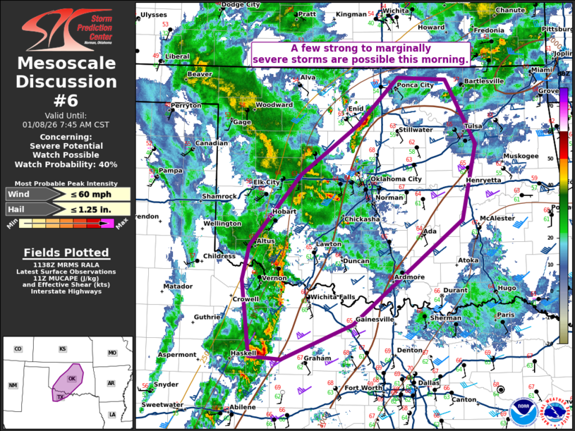
   SUMMARY...A few strong to marginally severe storms are possible this
   morning.

   DISCUSSION...Thunderstorms coverage has increased across West Texas
   and into Oklahoma this morning as isentropic ascent has strengthened
   with 1km flow now approaching 50 knots on the TLX VWP. Within this
   zone, MUCAPE around 1000 J/kg and effective shear of 55-60 knots
   will support some storm organization and stronger cells capable of
   isolated large hail. In addition, 61 to 63F dewpoints have spread
   northward across much of Oklahoma which has eroded inhibition across
   the state with around 500-750 J/kg MLCAPE. Overall, a messy storm
   mode and weak low-level lapse rates should limit the overall threat.
   Nonetheless, given the veered low-level wind profile, a brief
   tornado and/or gusty winds cannot be ruled out if a more established
   storm/mesocyclone can develop.

   ..Bentley/Mosier.. 01/08/2026

   ...Please see www.spc.noaa.gov for graphic product...

   ATTN...WFO...TSA...FWD...OUN...SJT...

   LAT...LON   34999604 33609779 33159892 33189943 34199955 34649945
               35589863 36249770 36869707 36849630 35989581 34999604

   MOST PROBABLE PEAK WIND GUST...UP TO 60 MPH
   MOST PROBABLE PEAK HAIL SIZE...UP TO 1.25 IN
|
|
|
Top/All Mesoscale Discussions/Forecast Products/Home |
|