| Mesoscale Discussion 52 | |
| < Previous MD Next MD > | |
|
|
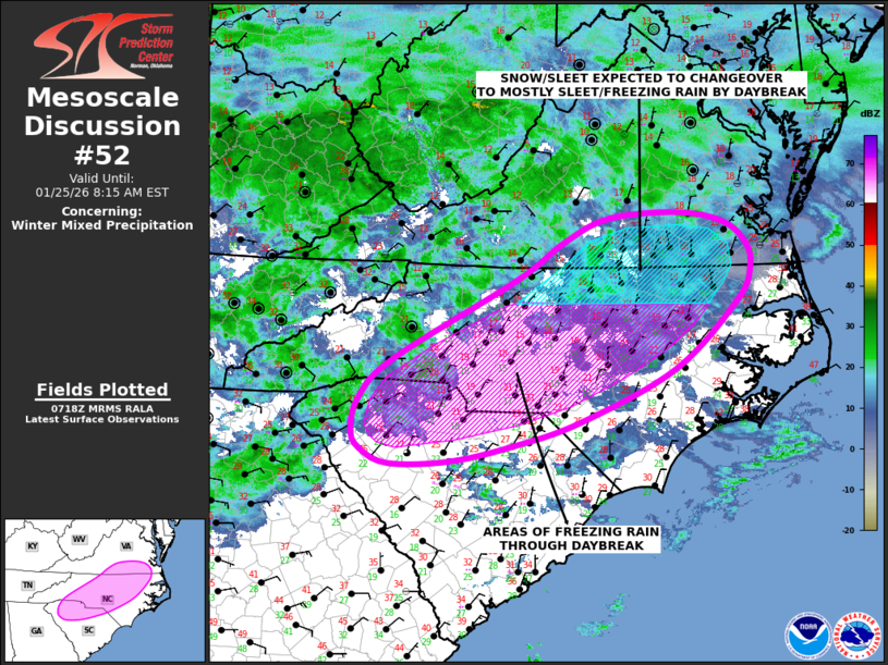
   Mesoscale Discussion 0052
   NWS Storm Prediction Center Norman OK
   0120 AM CST Sun Jan 25 2026

   Areas affected...Northern South Carolina...Central and Northern
   North Carolina...Southern Virginia

   Concerning...Winter mixed precipitation

   Valid 250720Z - 251315Z

   SUMMARY...Areas of freezing rain are expected through Sunday morning
   from South Carolina into southern and central North Carolina. From
   northern North Carolina into southern Virginia, a mix of snow and
   sleet is expected to changeover to a mix of sleet and freezing rain
   by daybreak.

   DISCUSSION...Latest water vapor imagery shows abundant mid-level
   moisture across most of the east-central U.S. within
   west-southwesterly flow aloft. A broad mid-level jet extends
   westward from the Northeast into the southern Great Lakes and Ohio
   Valley. Strong lift within the right entrance region of the jet
   combined with a broad zone of warm advection will continue to be
   favorable for widespread precipitation from the Ohio and Tennessee
   Valley eastward to the Eastern Seaboard. From the Carolinas
   northward, a sub-freezing airmass is in place but temperatures in
   the low to mid-levels are warm, with forecast soundings showing a
   warm nose just above 850 mb ranging from +5 To +10 C. This
   temperature profile will be favorable for freezing rain from South
   Carolina northward into southern and central North Carolina through
   daybreak.

   Further to the north across northern North Carolina and southern
   Virginia, low to mid-level temperatures are cold enough for a mix of
   snow and sleet. As strong warm advection continues over the next few
   hours, a gradual transition to sleet and freezing rain is expected.

   ..Broyles/Mosier.. 01/25/2026

   ...Please see www.spc.noaa.gov for graphic product...

   ATTN...WFO...AKQ...MHX...RAH...ILM...RNK...CAE...GSP...

   LAT...LON   34697911 34398011 34208103 34178191 34348233 34568245
               34968236 35428187 36398005 36857935 37127869 37197770
               37077700 36817666 36517661 36127680 35317772 34697911
|
|
|
Top/All Mesoscale Discussions/Forecast Products/Home |
|