| Mesoscale Discussion 45 | |
| < Previous MD | |
|
|
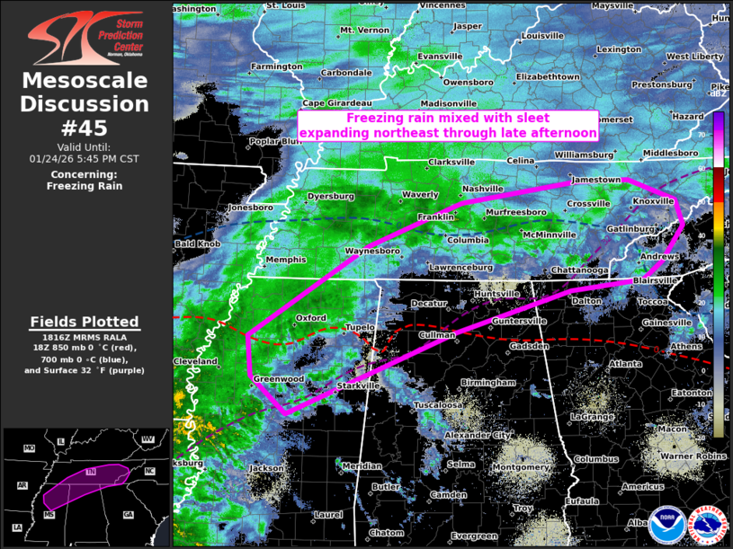
   Mesoscale Discussion 0045
   NWS Storm Prediction Center Norman OK
   1217 PM CST Sat Jan 24 2026

   Areas affected...northern MS to the southern Appalachians

   Concerning...Freezing rain

   Valid 241817Z - 242345Z

   SUMMARY...Freezing rain mixed with sleet is expected to expand
   across parts of the Tennessee Valley to the southern Appalachians
   through late afternoon. The most likely corridor for appreciable
   accretion appears centered on north-central Mississippi, northwest
   Alabama, and southeast Tennessee.

   DISCUSSION...A broad swath of mixed winter precip is ongoing from
   KY/TN southwest to LA. The initial leading activity has largely
   remained as sleet and snow, with greater liquid-equivalent rates in
   sleet, freezing rain, and rain over LA. This latter plume is
   expected to be the most prolific for freezing rain rates as it
   shifts northeast through late afternoon. Liquid-equivalent rates of
   .05 to .25 in/hr should remain common. Despite ample low-level
   isentropic ascent, guidance is quite insistent on expanding the
   above-freezing warm nose north-northeast across northern MS to
   eastern TN through 00Z. A 15Z UL-Monroe sounding sampled around 12C
   at 900 mb, indicative of a classic freezing rain/mixed sleet
   profile. The overall setup suggests that these should become the
   primary PTYPEs across central/northern MS through northwest AL to
   southeast TN.

   ..Grams.. 01/24/2026

   ...Please see www.spc.noaa.gov for graphic product...

   ATTN...WFO...GSP...MRX...FFC...OHX...BMX...HUN...MEG...JAN...

   LAT...LON   34209026 35448831 36048675 36338482 36348395 36048318
               35708306 35228341 34968374 34838495 34278684 33138962
               33659021 34209026
|
|
|
Top/All Mesoscale Discussions/Forecast Products/Home |
|