| Mesoscale Discussion 43 | |
| < Previous MD Next MD > | |
|
|
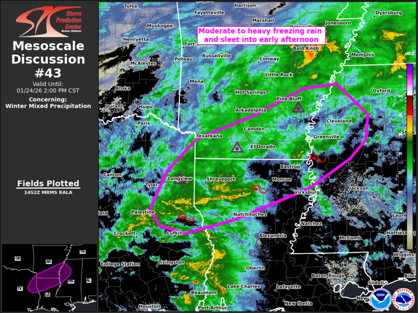
   Mesoscale Discussion 0043
   NWS Storm Prediction Center Norman OK
   0853 AM CST Sat Jan 24 2026

   Areas affected...northeast TX...southern AR...northern LA...western
   MS

   Concerning...Winter mixed precipitation

   Valid 241453Z - 242000Z

   SUMMARY...Moderate to heavy freezing rain and sleet are expected to
   persist across the Ark-La-Tex to Ark-La-Miss regions into early
   afternoon. Liquid-equivalent precipitation rates of a tenth to
   quarter-inch per hour should be common, locally up to a half-inch
   per hour.

   DISCUSSION...A swath of moderate to heavy mixed precipitation is
   ongoing across east TX and the Ark-La-Tex. Surface observations
   confirm hourly precipitation rates of .10-.25 in/hr are common, up
   to around .50 in/hr. 12Z guidance is rather consistent in indicating
   this swath of precip persisting through at least early afternoon,
   gradually shifting east-northeast amid rather pronounced low-level
   warm theta-e advection. A classic freezing rain to sleet sounding
   was sampled at 12Z in SHV. This type of thermodynamic profile should
   continue to steadily push southward in northern LA. Farther east,
   the surface freezing line should only drift to nearly stall across
   western MS into the early afternoon.

   ..Grams.. 01/24/2026

   ...Please see www.spc.noaa.gov for graphic product...

   ATTN...WFO...MEG...JAN...LZK...SHV...

   LAT...LON   31729303 31419426 31579489 31919514 32729473 33429402
               33959252 34529126 34619041 33938962 33408970 33009011
               32379116 31729303
|
|
|
Top/All Mesoscale Discussions/Forecast Products/Home |
|