| Mesoscale Discussion 42 | |
| < Previous MD Next MD > | |
|
|
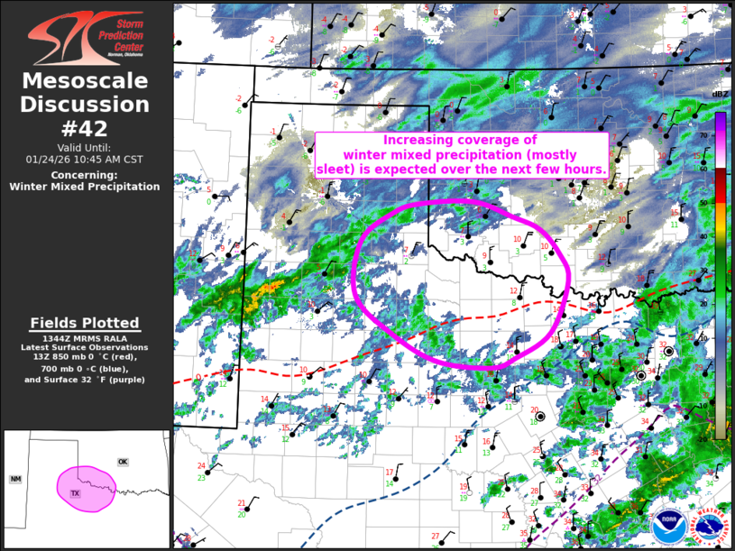
   Mesoscale Discussion 0042
   NWS Storm Prediction Center Norman OK
   0747 AM CST Sat Jan 24 2026

   Areas affected...Northwest TX...Southwest OK

   Concerning...Winter mixed precipitation

   Valid 241347Z - 241645Z

   SUMMARY...Increasing coverage of winter mixed precipitation (mostly
   sleet) is possible from northwest Texas into southwest Oklahoma over
   the next few hours.

   DISCUSSION...Deepening ascent is evident on satellite imagery from
   far west TX into northwest TX, downstream of a subtle shortwave
   trough moving through the southwesterly flow aloft well ahead of the
   upper low off the central Baja California coast. This deepening
   ascent has resulting in an expanding area of light to moderate
   precipitation now moving into northwest TX. Surface temperatures in
   this region are well-below freezing (i.e. lower teens to single
   digits), but forecast sounding still show a substantial warm nose.
   This profile appears to favor sleet, although some snow could be
   mixed in a well. As a result, mixed winter precipitation is
   anticipated from northwest TX into southwest TX over the next few
   hours. Precipitation rates will generally be light, but modestly
   steep lapse rates above the warm nose suggest some embedded moderate
   rates are possible.

   ..Mosier.. 01/24/2026

   ...Please see www.spc.noaa.gov for graphic product...

   ATTN...WFO...FWD...OUN...SJT...LUB...AMA...

   LAT...LON   32889896 32979985 33350059 33870119 34630112 35010059
               35140013 35189924 34979859 34799814 34459781 34089767
               33379798 33019856 32889896
|
|
|
Top/All Mesoscale Discussions/Forecast Products/Home |
|