| Mesoscale Discussion 38 | |
| < Previous MD Next MD > | |

|
|
   Mesoscale Discussion 0038
   NWS Storm Prediction Center Norman OK
   1126 PM CST Fri Jan 23 2026

   Areas affected...The Texarkana Region into southern Arkansas and far
   western Mississippi

   Concerning...Freezing rain

   Valid 240526Z - 241030Z

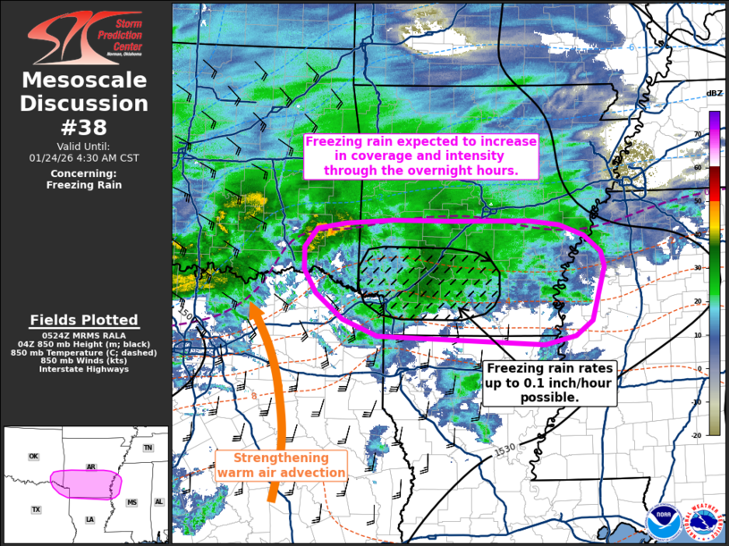
   SUMMARY...Freezing rain rates are expected to increase across the
   Texarkana region into southern Arkansas and far western Mississippi
   through the overnight hours. Freezing rain rates between 0.05 to 0.1
   inch/hour are possible.

   DISCUSSION...Surface temperatures across southern AR into the
   Texarkana region are now mostly below freezing despite a slight
   abatement of near-surface cold air advection. Several ASOS/AWOS
   stations, mPING reports, and web cams have been reporting
   predominantly freezing rain with pockets of embedded sleet over the
   past couple of hours. Looking upstream, a heavier precipitation band
   is noted migrating eastward across north TX/southern OK attendant to
   a focused zone of isentropic and frontogenetical ascent at around
   850 mb. This uptick in low-level warm advection is noted in regional
   VWPs as a steady enlargement of the 0-3 km hodograph, which supports
   recent analyses and forecasts.

   Further strengthening of warm advection/frontogenetical ascent at
   around the 850 mb level is expected per recent guidance as the
   precipitation band spreads east into southern AR over the next 4-6
   hours. Strong ascent combined with persistent warm temperatures at
   around 700 mb will maintain a broad swath of freezing rain across
   the Texarkana region into southern AR, and will likely promote the
   onset of freezing rain to far western MS. Freezing rain rates on the
   order of 0.05 inch/hour appear likely, but localized rates up to 0.1
   inch/hour appear possible across southwest/south-central AR where
   CAM consensus for the past few hours has depicted the highest QPF
   amounts (which appear reasonable based on observed banding
   upstream).

   ..Moore.. 01/24/2026

   ...Please see www.spc.noaa.gov for graphic product...

   ATTN...WFO...MEG...JAN...LZK...SHV...TSA...FWD...

   LAT...LON   32889136 32999414 33229473 33589517 33919537 34229537
               34489517 34579469 34619391 34609290 34609163 34559112
               34399070 34179042 33959036 33219058 32999086 32889136
|
|
|
Top/All Mesoscale Discussions/Forecast Products/Home |
|