| Mesoscale Discussion 37 | |
| < Previous MD Next MD > | |
|
|
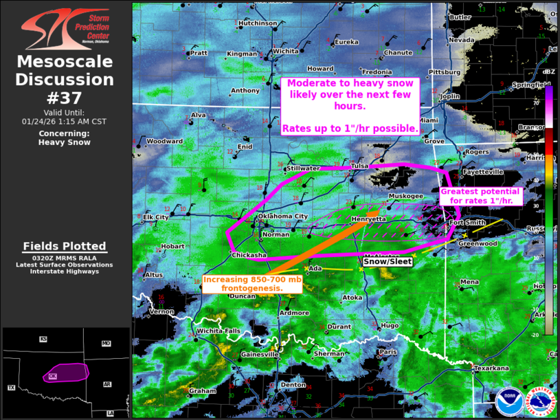
   Mesoscale Discussion 0037
   NWS Storm Prediction Center Norman OK
   0922 PM CST Fri Jan 23 2026

   Areas affected...central and eastern Oklahoma into far west-central
   Arkansas

   Concerning...Heavy snow

   Valid 240322Z - 240715Z

   SUMMARY...Moderate to heavy snowfall to increase in coverage through
   the evening. Rates 1"/hr will be possible.

   DISCUSSION...Snowfall has increased in coverage across portions of
   central Oklahoma over the last hour, with some reports of moderate
   snow south of the Oklahoma City metro. Correlation coefficient in
   recent radar imagery shows a transition zone of primarily snow and
   sleet south of I-40 from roughly northern Pontotoc County north and
   east to northern Le Flore County near the Arkansas state line.

   Initially, drier air was in place with larger dew point spreads but
   moistening has been observed with rising dew points and implied
   saturating profile which will has lead to an increase in snowfall
   rates over the last hour. Moderate to locally heavy snowfall can be
   expected to expand in coverage over the next few hours across
   central/northeastern Oklahoma with occasional rates around 1"/hr.

   Through the evening into early Saturday morning, increasing 850-700
   mb frontogenesis will increase across a zone from south-central
   Oklahoma into eastern Oklahoma/western Arkansas across a strong warm
   advection zone. As moistening continues to occur further east amid
   this favorable ascent zone, snowfall rates should increase, with
   likely rates around 1"/hr along the I-40 corridor around 06-09z.

   ..Thornton.. 01/24/2026

   ...Please see www.spc.noaa.gov for graphic product...

   ATTN...WFO...TSA...OUN...

   LAT...LON   35239441 35059512 35019659 34949750 34989767 35049790
               35309801 35759737 35979712 36179665 36209590 36239511
               36199467 36119440 35549421 35239441
|
|
|
Top/All Mesoscale Discussions/Forecast Products/Home |
|