| Mesoscale Discussion 34 | |
| < Previous MD | |
|
|
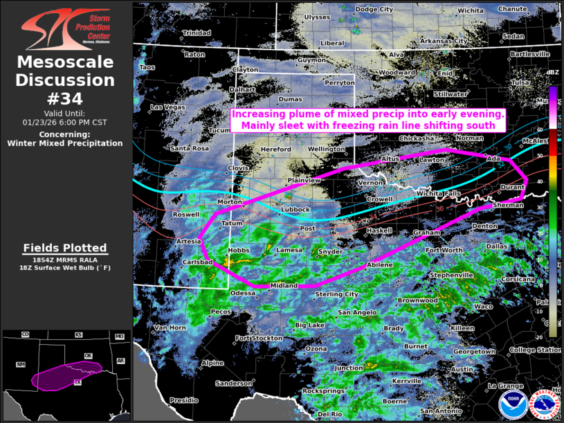
   Mesoscale Discussion 0034
   NWS Storm Prediction Center Norman OK
   1255 PM CST Fri Jan 23 2026

   Areas affected...west to north TX and southern OK

   Concerning...Winter mixed precipitation

   Valid 231855Z - 240000Z

   SUMMARY...A plume of mixed precipitation is expected to
   substantially increase into early evening from west to north Texas
   into southern Oklahoma. Sleet should be the primary precipitation
   type, with the freezing rain line gradually shifting south. Initial
   rates should generally be light, before increasing tonight.

   DISCUSSION...Initial swath of precipitation has been increasing over
   the past few hours across the South Plains to central TX. The
   northern extent of this precip shield is about to overspread a
   southward-moving nose of sub-freezing surface temperatures across
   the Low Rolling Plains, centered on the surface ridge over northwest
   TX. This should initially impact areas near to southeast of LBB, but
   will increase greatly in areal coverage by late afternoon into early
   evening. Light freezing rain should be anticipated where surface
   temps remain in the 29-32 F range. Sleet should be the overarching
   PTYPE through 00Z as low-level warm theta-e advection in the 850-700
   mb layer maintains an above-freezing warm nose atop the increasingly
   cold boundary layer. Pervasive surface dry advection will slow the
   northern extent of winter precip reaching the surface, especially in
   OK, through early evening. This should also aid in yielding
   generally light liquid-equivalent rates until tonight.

   ..Grams.. 01/23/2026

   ...Please see www.spc.noaa.gov for graphic product...

   ATTN...WFO...TSA...FWD...OUN...SJT...LUB...MAF...ABQ...

   LAT...LON   32100095 32060243 32580359 33040380 33540343 34530026
               34909770 34659610 34229569 33839585 33669688 32479983
               32100095
|
|
|
Top/All Mesoscale Discussions/Forecast Products/Home |
|