| Mesoscale Discussion 32 | |
| < Previous MD | |
|
|
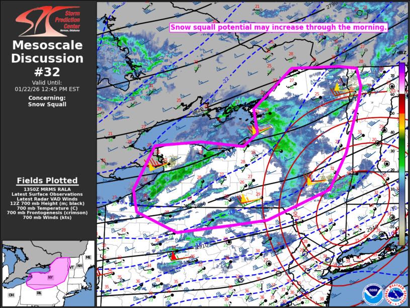
   Mesoscale Discussion 0032
   NWS Storm Prediction Center Norman OK
   0752 AM CST Thu Jan 22 2026

   Areas affected...Northern PA into parts of Upstate NY and western VT

   Concerning...Snow Squall

   Valid 221352Z - 221745Z

   SUMMARY...Snow squall potential may increase through the morning.

   DISCUSSION...Locally heavy snow showers are ongoing this morning
   from western NY into northern PA, within a broader region of deep
   cyclonic flow covering the Great Lakes region. Modest diurnal
   warming beneath cold temperatures aloft (near/below -20C at 700 mb)
   will steepen low-level lapse rates with time this morning,
   especially across parts of western/northern NY. While low-level
   forcing will remain relatively subtle, multiple shallow convective
   bands may continue to develop, especially downstream of Lake Erie
   and Lake Ontario. Any stronger bands may persist as they move
   eastward, with recent HRRR/RRFS runs both depicting multiple bands
   moving across parts of northern NY later this morning into the early
   afternoon.

   Any stronger bands will be capable of producing briefly heavy snow
   rates. Strengthening west-southwesterly boundary-layer flow will
   also support strong gust potential, especially where more pronounced
   steepening of low-level lapse rates occurs. This combination of wind
   and briefly heavy snow will result in potential for abrupt
   visibility reductions through the morning into at least the early
   afternoon.

   ..Dean.. 01/22/2026

   ...Please see www.spc.noaa.gov for graphic product...

   ATTN...WFO...BTV...ALY...BGM...BUF...CTP...CLE...

   LAT...LON   41447842 41867961 42347973 43317914 43427777 43337651
               43617608 44137621 45027504 45037361 44987307 44587295
               44277304 43177346 42377396 41727581 41617680 41447842
|
|
|
Top/All Mesoscale Discussions/Forecast Products/Home |
|