| Mesoscale Discussion 30 | |
| < Previous MD | |
|
|
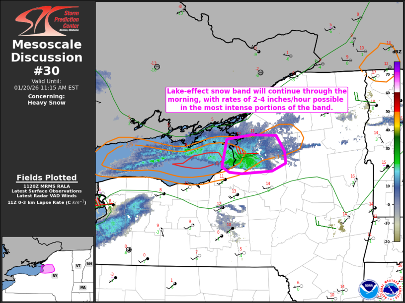
   Mesoscale Discussion 0030
   NWS Storm Prediction Center Norman OK
   0522 AM CST Tue Jan 20 2026

   Areas affected...Eastern shore of Lake Ontario into the Tug Hill
   Plateau

   Concerning...Heavy snow

   Valid 201122Z - 201615Z

   SUMMARY...A heavy lake-effect snow band will continue through the
   morning, with rates of 2-4 inches/hour possible in the most intense
   portions of the band.

   DISCUSSION...A well-established lake-effect snow band is ongoing
   from Lake Ontario into parts of the Tug Hill Plateau this morning.
   While some north-south oscillations will be possible as a minor
   midlevel shortwave trough approaches from the west, this band is
   expected to persist through the morning. A favorably long fetch off
   of Lake Ontario and a relatively deep convective boundary layer will
   continue to favor very heavy snow rates within the most intense
   portions of the band.

   Short-term guidance indicates that midlevel temperatures will reach
   a minimum (-32 to -33 C at 700 mb) by mid/late morning, and snow
   rates of 2-4 inches/hour will continue to be possible through this
   time frame. Some warming aloft and modest lowering of equilibrium
   levels is eventually expected in the wake of the approaching
   shortwave trough, but the favorable fetch will help to maintain this
   band through much of the day.

   ..Dean.. 01/20/2026

   ...Please see www.spc.noaa.gov for graphic product...

   ATTN...WFO...ALY...BGM...BUF...

   LAT...LON   43977635 44047581 44027529 43777512 43597509 43477539
               43437602 43467629 43547644 43977635
|
|
|
Top/All Mesoscale Discussions/Forecast Products/Home |
|