| Mesoscale Discussion 29 | |
| < Previous MD | |
|
|
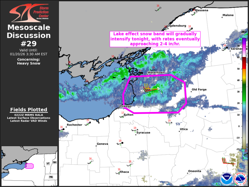
   Mesoscale Discussion 0029
   NWS Storm Prediction Center Norman OK
   0824 PM CST Mon Jan 19 2026

   Areas affected...Downwind of Lake Ontario

   Concerning...Heavy snow

   Valid 200224Z - 200830Z

   SUMMARY...A lake effect snow band will gradually intensify tonight,
   with rates eventually approaching 2-4 inches per hour downwind of
   Lake Ontario.

   DISCUSSION...The latest radar imagery from KTYX shows gradually
   organizing lake effect snow bands extending downwind of Lake
   Ontario. This is in response to subtle veering of uni-directional
   boundary-layer flow (sampled by KTYX VWP) and a favorable fetch
   developing across the long axis of Lake Ontario. This trend will
   continue over the next few hours, as a low-level cyclone and
   southward-extending surface trough continue advancing
   east-northeastward across Quebec. Additionally, cooling temperatures
   aloft (around -31C at 700 mb) will result in a deepening convective
   boundary layer -- further aiding in the intensification of lake
   effect snow bands extending across the Tug Hill Plateau and
   vicinity. Heavy snowfall rates of around 2-4 inches per hour are
   expected to begin in the 04-06Z time frame, and should continue
   through the early morning hours.

   ..Weinman.. 01/20/2026

   ...Please see www.spc.noaa.gov for graphic product...

   ATTN...WFO...ALY...BGM...BUF...

   LAT...LON   43947626 43977539 43857511 43537507 43387524 43387618
               43467640 43667642 43947626
|
|
|
Top/All Mesoscale Discussions/Forecast Products/Home |
|