| Mesoscale Discussion 28 | |
| < Previous MD | |
|
|
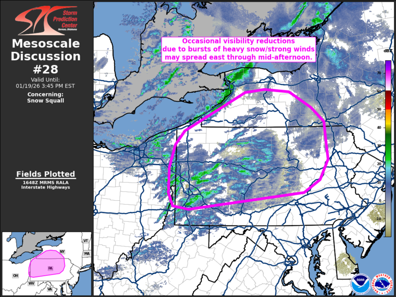
   Mesoscale Discussion 0028
   NWS Storm Prediction Center Norman OK
   1050 AM CST Mon Jan 19 2026

   Areas affected...Pennsylvania into western New York

   Concerning...Snow Squall

   Valid 191650Z - 192045Z

   SUMMARY...Occasional visibility reductions associated with
   moderate/heavy snow showers and gusty winds may spread east across
   parts of Pennsylvania and into western New York through the
   afternoon.

   DISCUSSION...A cluster of snow showers migrating across eastern OH
   and western PA over the past few hours have yielded occasional
   visibility reductions down to 1/4 mile per regional web cams and
   ASOS observations. These visibility reductions are largely being
   driven by moderate to heavy snowfall rates within shallow, but
   convectively augmented, snow showers ahead of a progressive
   mid-level wave evident in GOES imagery. Strong cold advection
   through 850 mb will continue to support 25-35 mph wind gusts, which
   will further contribute to periods of low visibility by blowing
   falling snow and the antecedent snow pack in place across western
   PA. As such, periods of snow squall conditions should spread
   east/northeast through mid-afternoon in tandem with the upper wave
   and the surging low-level cold air mass.

   ..Moore.. 01/19/2026

   ...Please see www.spc.noaa.gov for graphic product...

   ATTN...WFO...BGM...BUF...CTP...PBZ...CLE...

   LAT...LON   40088011 40158059 40468072 41068072 41588055 41898026
               42797841 42867780 42807704 42447635 42117596 41627592
               41247586 40767613 40477662 40088011
|
|
|
Top/All Mesoscale Discussions/Forecast Products/Home |
|