| Mesoscale Discussion 27 | |
| < Previous MD | |
|
|
Mesoscale Discussion 0027
NWS Storm Prediction Center Norman OK
0848 AM CST Sun Jan 18 2026
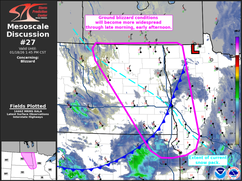
Areas affected...Eastern North Dakota...northeast South
Dakota...northwest Minnesota
Concerning...Blizzard
Valid 181448Z - 181945Z
SUMMARY...Ground blizzard conditions are expected to become more
widespread through late morning/early afternoon across eastern North
Dakota, northwest Minnesota, and far northeast South Dakota.
DISCUSSION...14z surface observations show northerly winds beginning
to increase to 25-35 mph across northeast ND and far northwest MN as
a very cold (-5 to 5 F) air mass begins to push southward into the
Red River Valley of the North. Based on current wind speeds,
temperatures, and the condition of the existing snow pack (per NORSC
analyses), blowing snow model output suggests that visibility
reductions to 1/4 mile or less should become increasingly common,
especially in open country. This is supported by recent web/plow
cams across the region that depict somewhat reduced visibility
within towns/sheltered areas but significant reductions in open
country. Reflectivity data from upstream radars in southern Manitoba
are also depicting light reflectivity streamers often indicative of
plumes of blowing snow which likely correlate with the most
significant visibility reductions.
These conditions should become more widespread through the late
morning and early afternoon as the arctic air mass continues to
surge south - especially as wind speeds increase into the 30-35 mph
range, which should correlate with scattered to widespread ground
blizzard conditions per blowing snow model output. Similar wind
speeds were observed yesterday and resulted in sustained 1/4 to 1/2
mile visibility reductions, so confidence is high in ground blizzard
impacts, even into areas immediately south of the existing snow
pack.
..Moore.. 01/18/2026
...Please see www.spc.noaa.gov for graphic product...
ATTN...WFO...MPX...FGF...ABR...BIS...
LAT...LON 49030012 49079652 48979623 45859548 45419566 45229614
45139680 45139734 45389788 48450071 48850087 49030070
49030012
|
|
|
Top/All Mesoscale Discussions/Forecast Products/Home |
|