| Mesoscale Discussion 25 | |
| < Previous MD | |
|
|
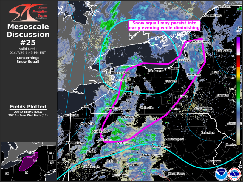
   Mesoscale Discussion 0025
   NWS Storm Prediction Center Norman OK
   0238 PM CST Sat Jan 17 2026

   Areas affected...western/central NY and northern PA

   Concerning...Snow Squall

   Valid 172038Z - 172345Z

   SUMMARY...Long-lived snow squall may persist into early evening,
   while likely diminishing in areal extent/intensity.

   DISCUSSION...A long-lived snow squall which began west of Cleveland,
   has recently passed through the Buffalo Metro Area, with numerous
   first-order observing sites along Lake Erie having recorded
   half-mile or less visibilities and gusts of 30-40 kts. More sporadic
   snow squall conditions have been noted along the trailing portion of
   the band that is now in western PA. A pocket of warmer surface
   temperatures in western NY may help sustain the squall near the Lake
   Ontario vicinity into early evening before more prominent weakening
   of lapse rates. Large-scale mid-level warming will lower inversion
   heights and combined with the onset of nocturnal surface cooling,
   these factors should aid in the squall diminishing. This is
   supported by latest RAP/early-afternoon CAM guidance with a
   reduction in the snow-squall parameter and simulated reflectivity
   trends towards 00Z.

   ..Grams.. 01/17/2026

   ...Please see www.spc.noaa.gov for graphic product...

   ATTN...WFO...BGM...BUF...CTP...PBZ...

   LAT...LON   42967861 43257840 43437779 43397683 43607640 44027616
               44107553 43437542 42617619 41987692 41617771 41317823
               41227858 41217921 41387937 41677928 42487874 42967861
|
|
|
Top/All Mesoscale Discussions/Forecast Products/Home |
|