| Mesoscale Discussion 2286 | |
| < Previous MD | |
|
|
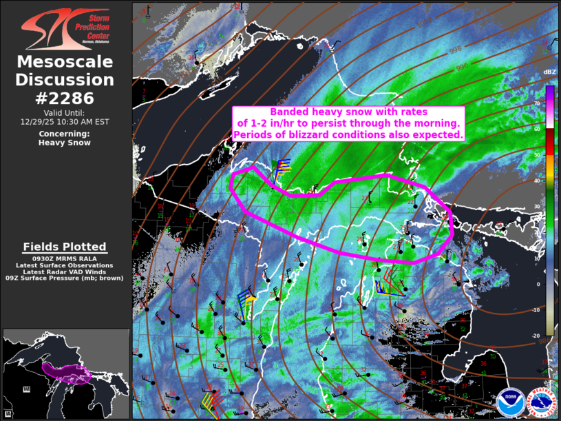
   Mesoscale Discussion 2286
   NWS Storm Prediction Center Norman OK
   0332 AM CST Mon Dec 29 2025

   Areas affected...Parts of Upper Michigan and far northern Lower
   Michigan

   Concerning...Heavy snow

   Valid 290932Z - 291530Z

   SUMMARY...Banded heavy snow with rates of 1-2 inches per hour and
   periods of blizzard conditions are expected through the morning
   hours.

   DISCUSSION...To the west/northwest of a very deep low pressure
   system (983 mb surface low over Lake Huron), substantial deep-layer
   lift is overspreading a cold, deeply saturated profile over Upper MI
   and vicinity. The combination of this lift through a deep/saturated
   DGZ and isothermal layer below will promote efficient crystal growth
   and aggregation. As as result, widespread and prolonged heavy
   snowfall rates of 1-1.5 inches per hour are expected, with even
   higher rates to around 2 inches per hour over the higher terrain and
   beneath the core of more organized banding. In addition to these
   substantial and prolonged rates, a very tight pressure gradient
   peripheral to the deep surface low and strong low-level jet
   (50-60-kt flow in the lowest 1 km AGL per MQT VWP) will promote
   40-50 mph gusts and intermittent blizzard conditions in conjunction
   with the heavy snowfall rates.

   ..Weinman.. 12/29/2025

   ...Please see www.spc.noaa.gov for graphic product...

   ATTN...WFO...APX...MQT...

   LAT...LON   45458526 45558610 45788701 46168815 46508849 46718842
               46828799 46578760 46408716 46428653 46618622 46738507
               46538424 46158371 45818366 45538398 45398451 45458526
|
|
|
Top/All Mesoscale Discussions/Forecast Products/Home |
|