| Mesoscale Discussion 2280 | |
| < Previous MD Next MD > | |
|
|
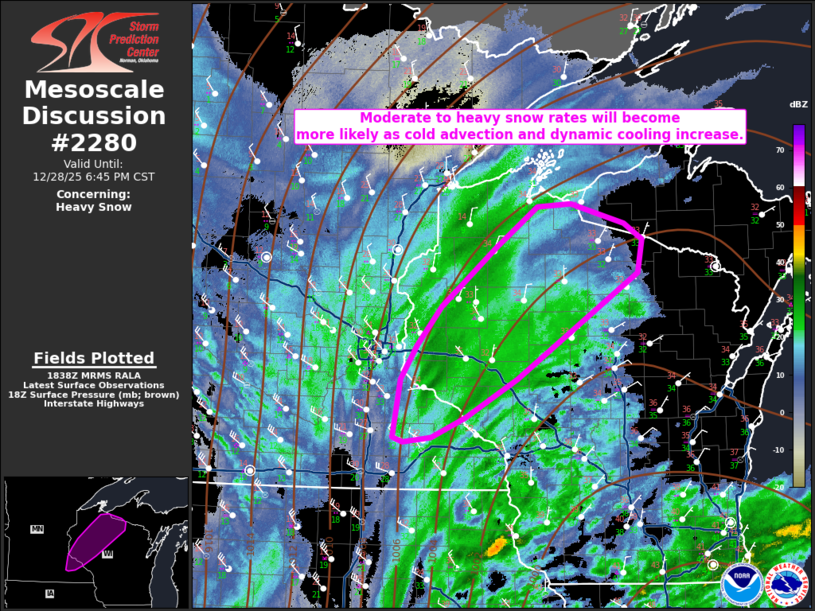
   Mesoscale Discussion 2280
   NWS Storm Prediction Center Norman OK
   1240 PM CST Sun Dec 28 2025

   Areas affected...Southeast Minnesota into northwest/northern
   Wisconsin

   Concerning...Heavy snow

   Valid 281840Z - 290045Z

   SUMMARY...Conditions will initially be marginal for heavier snowfall
   rates, but cooling temperatures at the surface and aloft will
   increase potential for snowfall rates to around 1 inch per hour.

   DISCUSSION...As the mid-level jet intensifies in the central Plains,
   a surface low continues to deepen in northern Illinois. Cold air
   advection is increasing within the upper Mississippi Valley in
   response. Furthermore, deep-layer lift is also increasing as
   evidenced by a broad area of precipitation moving into parts of
   northwest/northern Wisconsin. While temperatures in some areas have
   been just above freezing for most of the morning, recent surface
   observations have shown decreasing temperatures/dewpoints. Dynamic
   cooling within the heavier precipitation bands has also been
   evident. That said, snowfall should increase through the afternoon.
   Observations from Eau Claire and Hayward already show moderate
   snowfall occurring. As the atmospheric profile continues to cool,
   the environment should become more favorable for snowfall rates up
   to around 1 inch per hour through late afternoon/early evening.

   ..Wendt.. 12/28/2025

   ...Please see www.spc.noaa.gov for graphic product...

   ATTN...WFO...MQT...GRB...DLH...ARX...MPX...

   LAT...LON   46479079 46509029 46298948 46128922 45778928 44679108
               44269186 44049236 43999277 44059292 44669282 45029257
               45429221 46059139 46479079
|
|
|
Top/All Mesoscale Discussions/Forecast Products/Home |
|