| Mesoscale Discussion 2278 | |
| < Previous MD Next MD > | |
|
|
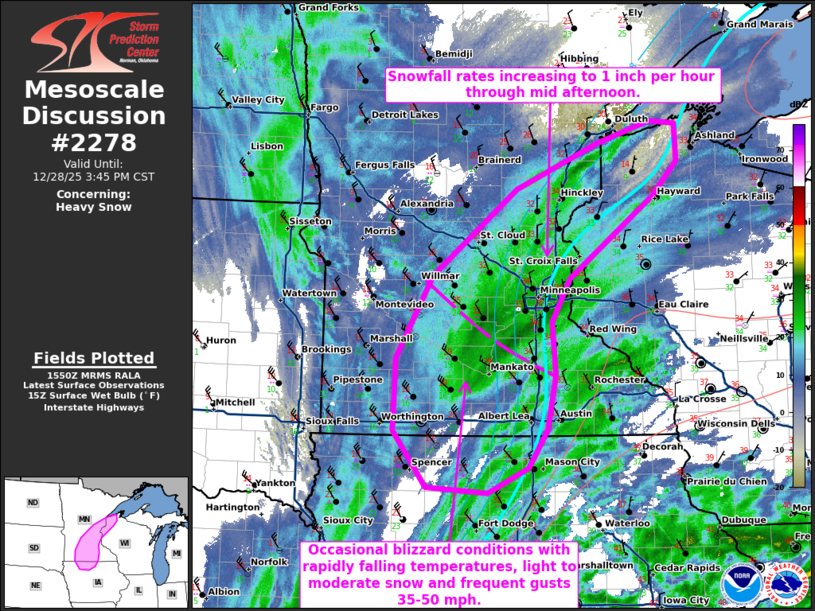
   Mesoscale Discussion 2278
   NWS Storm Prediction Center Norman OK
   0952 AM CST Sun Dec 28 2025

   Areas affected...North central Iowa...southern and eastern Minnesota
   and northwestern Wisconsin

   Concerning...Heavy snow

   Valid 281552Z - 282145Z

   SUMMARY...Heavy snow, with rates near 1 inch per hour, is expected
   to develop by midday in east central Minnesota and northwest
   Wisconsin.  Occasional blizzard conditions are expected into
   southern Minnesota and northern Iowa.

   DISCUSSION...Gradual erosion of a warm nose (noted in the 12z MPX
   sounding) will continue through the afternoon from eastern MN into
   northwest WI as a result of strengthening ascent and
   cooling/saturation of profiles to the northwest of a deepening
   cyclone now near the IA/MO/IL border.  Near-surface cooling from
   northwest-to-southeast will become more favorable for
   accumulating/heavy snow from east central MN into northwest WI
   within the primary deformation band, while snowfall rates will be
   lower farther southwest into southern MN/northern IA.  However, a
   strengthening pressure gradient and rapidly falling temperatures
   into the teens/single digits will result in blowing snow and
   blizzard conditions (frequent gusts 35-50 mph with visibility
   reduced to 1/4 mi or less) from southern MN/northern IA through the
   afternoon.

   ..Thompson.. 12/28/2025

   ...Please see www.spc.noaa.gov for graphic product...

   ATTN...WFO...DLH...ARX...MPX...DMX...FSD...

   LAT...LON   44149300 43569311 43169339 42899399 42959490 43549539
               44319536 45199483 46129356 46609234 46829155 46809116
               46409115 46039152 45179278 44709305 44149300
|
|
|
Top/All Mesoscale Discussions/Forecast Products/Home |
|