| Mesoscale Discussion 2276 | |
| < Previous MD | |

|
|
   Mesoscale Discussion 2276
   NWS Storm Prediction Center Norman OK
   0541 PM CST Fri Dec 26 2025

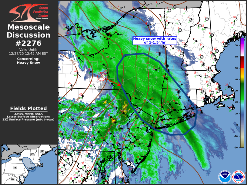
   Areas affected...Upstate NY to eastern Long Island...including parts
   of southern New England

   Concerning...Heavy snow

   Valid 262341Z - 270545Z

   SUMMARY...Heavy snow bands will spread/develop southeast across
   upstate NY toward southern New England over the next few hours. Snow
   rates of 1-1.5"/hr are expected.

   DISCUSSION...Low-amplitude short-wave trough is progressing
   southeast across western NY/PA early this evening. Latest
   water-vapor imagery depicts a notable midlevel vort max southwest of
   Syracuse, and this is reflected well in radar data. Multiple heavy
   snow bands have developed ahead of this vort max, strongly
   influenced by low-level warm advection, extending across upstate NY
   into the lower Hudson Valley. Boundary layer moistening supports
   this with dew points now rising into the mid teens (F) where snow
   rates are increasing. Over the next few hours snow rates are
   expected to increase downstream across western CT and Long Island,
   largely in response to this well-defined short wave digging toward
   the northern Middle Atlantic. Snow rates of 1-1.5"/hr can be
   expected prior to the short wave passage.

   ..Darrow.. 12/26/2025

   ...Please see www.spc.noaa.gov for graphic product...

   ATTN...WFO...BOX...OKX...ALY...PHI...BGM...

   LAT...LON   40917449 41497505 42417571 42857574 43277537 43347441
               43037362 41847235 41217180 40677192 40367243 40347311
               40527380 40917449
|
|
|
Top/All Mesoscale Discussions/Forecast Products/Home |
|