| Mesoscale Discussion 2273 | |
| < Previous MD Next MD > | |
|
|
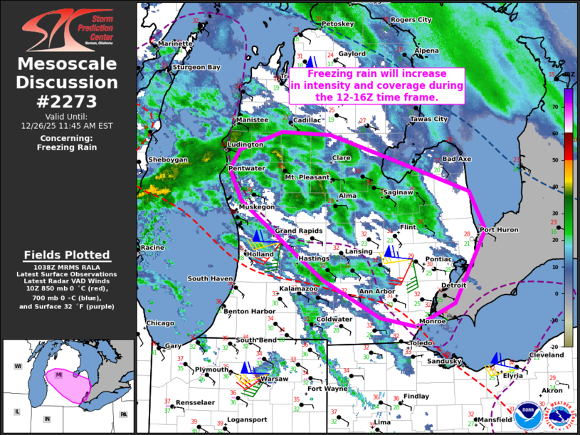
   Mesoscale Discussion 2273
   NWS Storm Prediction Center Norman OK
   0440 AM CST Fri Dec 26 2025

   Areas affected...Parts of central and southern Lower Michigan

   Concerning...Freezing rain

   Valid 261040Z - 261645Z

   SUMMARY...Freezing rain will increase in intensity and coverage
   while spreading eastward across parts of central and southern Lower
   Michigan during the 12-16Z time frame.

   DISCUSSION...The latest mosaic radar data shows a swath of mixed
   precipitation spreading eastward into Lower MI -- where surface
   pressure is falling rapidly (-4 to -5 mb in the last two hours over
   west-central Lower MI). This activity is focused ahead of an
   eastward-advancing shortwave trough and within a broad zone of
   low-level warm advection. As the trough continues eastward this
   morning and gains some amplitude, deep-layer forcing for ascent will
   strengthen while focusing over Lower MI. As a result, precipitation
   will increase in both intensity and coverage as the low/mid-levels
   saturate amid the strengthening ascent. Additionally, steepening
   midlevel lapse rates should yield weak elevated buoyancy and a
   potential convective enhancement to precipitation rates.

   As low-level warm advection strengthens, a substantial warm nose
   centered around 850 mb will favor complete melting of descending
   hydrometeors before re-freezing at the surface. The strong lift
   (with potential convective enhancement) and aforementioned thermal
   profile will contribute to freezing rain rates upwards of 0.05
   inches per hour (locally higher under the more robust convectively
   enhanced cores). The onset of the heavier rates is expected between
   12-16Z, but should persist beyond that period while spreading
   eastward across southeastern Lower MI.

   ..Weinman.. 12/26/2025

   ...Please see www.spc.noaa.gov for graphic product...

   ATTN...WFO...DTX...APX...GRR...

   LAT...LON   42448488 42888549 43378619 43738637 43958622 44168555
               44138477 43868383 43478256 43038230 42188279 41918342
               42018398 42448488
|
|
|
Top/All Mesoscale Discussions/Forecast Products/Home |
|