| Mesoscale Discussion 2270 | |
| < Previous MD Next MD > | |
|
|
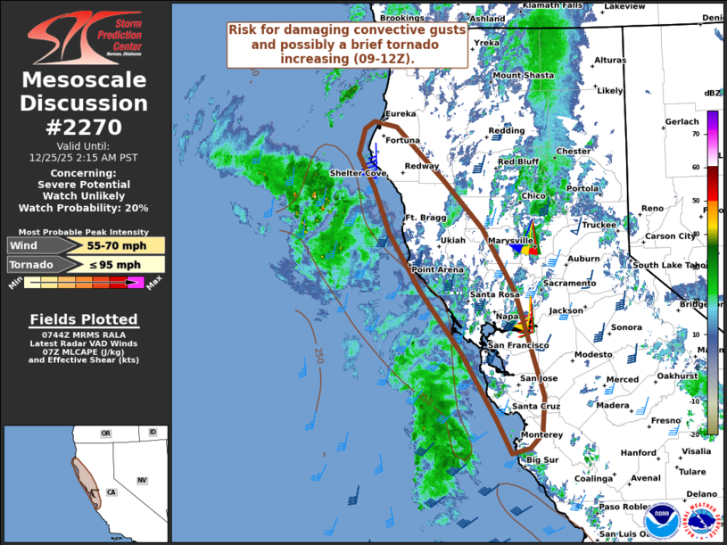
   Mesoscale Discussion 2270
   NWS Storm Prediction Center Norman OK
   0146 AM CST Thu Dec 25 2025

   Areas affected...Parts of the North Coast of California

   Concerning...Severe potential...Watch unlikely

   Valid 250746Z - 251015Z

   Probability of Watch Issuance...20 percent

   SUMMARY...The risk for damaging convective gusts and possibly a
   brief tornado is increasing, with the greatest threat expected
   between 09-12Z.

   DISCUSSION...As of 0730Z, radar data from KMUX shows an expansive,
   strongly forced band of stratiform rain with gradually
   deepening/intensifying convective elements. As a robust
   negative-tilt shortwave trough and accompanying jet continue toward
   the coast, this activity will spread east-northeastward into the
   North Coast of California during the 09-12Z time frame. Despite
   limited buoyancy, the strong forcing for ascent and strengthening
   deep-layer flow/shear should favor a modest uptick in convective
   organization/intensity as it approaches the coast. Given the
   strongly forced nature and 50+ kt flow in the lowest 1 km AGL, the
   primary concern will be damaging wind gusts. However, a brief
   tornado cannot be ruled out, aided by upwards of 200 m2/s2 0-1 km
   SRH and at least neutral boundary-layer static stability along the
   immediate coastal areas.

   ..Weinman/Smith.. 12/25/2025

   ...Please see www.spc.noaa.gov for graphic product...

   ATTN...WFO...STO...MTR...EKA...

   LAT...LON   36862224 37742283 38562351 39312403 39912430 40352457
               40682447 40782431 40702392 40392355 40002312 39372247
               38552192 37162146 36682149 36502170 36432200 36862224

   MOST PROBABLE PEAK TORNADO INTENSITY...UP TO 95 MPH
   MOST PROBABLE PEAK WIND GUST...55-70 MPH
|
|
|
Top/All Mesoscale Discussions/Forecast Products/Home |
|