| Mesoscale Discussion 2264 | |
| < Previous MD | |

|
|
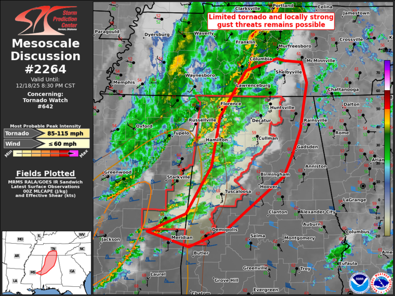
Mesoscale Discussion 2264 NWS Storm Prediction Center Norman OK 0654 PM CST Thu Dec 18 2025 Areas affected...parts of the Deep South Concerning...Tornado Watch 642... Valid 190054Z - 190230Z The severe weather threat for Tornado Watch 642 continues. SUMMARY...Limited tornado and strong gust threats should persist for at least a few more hours as broken bands of thunderstorms consolidate into a line, with the greatest potential across east-central Mississippi into western Alabama. An additional WW issuance is unlikely. DISCUSSION...Earlier supercells have largely diminished, but one is still ongoing in Newton County, MS. The east-central MS/western AL area will have the primary near-term tornado threat, owing to its proximity to modest but weakening buoyancy sampled by the 00Z JAN sounding. 5.5 to 6 C/km mid-level lapse rates in the JAN/BNA/BMX soundings will remain a limiting factor to more intense updrafts. But enlarged low-level hodographs and persistent low 60s surface dew points will support potential for a tornado or two. Farther north-northeast, faster propagation of cold front convection relative to the pre-frontal swath should yield consolidation into a QLCS that progresses towards the southern Appalachians. Strong gusts capable of locally damaging winds should be the main threat as surface-based instability becomes negligible, east and north of central AL where mid to upper 50s surface dew points persist. ..Grams/Smith.. 12/19/2025 ...Please see www.spc.noaa.gov for graphic product... ATTN...WFO...MRX...OHX...BMX...HUN...MOB...JAN... LAT...LON 32538919 32868837 33718783 34618766 35068736 35468708 35688639 35648624 35608585 35238575 34808582 34388589 33958607 33538627 32948704 32568752 32408794 32258830 32538919 MOST PROBABLE PEAK TORNADO INTENSITY...85-115 MPH MOST PROBABLE PEAK WIND GUST...UP TO 60 MPH |
|
|
Top/All Mesoscale Discussions/Forecast Products/Home |
|