| Mesoscale Discussion 2259 | |
| < Previous MD Next MD > | |
|
|
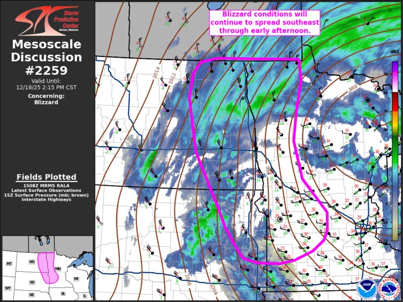
   Mesoscale Discussion 2259
   NWS Storm Prediction Center Norman OK
   0909 AM CST Thu Dec 18 2025

   Areas affected...The Eastern Dakotas into west and northwest
   Minnesota

   Concerning...Blizzard

   Valid 181509Z - 182015Z

   SUMMARY...Blizzard conditions are expected to continue across parts
   of the eastern Dakotas and into parts of west/northwest MN through
   early/mid afternoon.

   DISCUSSION...Latest surface observations and web cams from southeast
   SD northward through the Red River Valley of the north show
   widespread visibility reductions to 1/4 mile or less with some areas
   experiencing white out conditions - especially across northeast ND
   into northwest MN where moderate to heavy snowfall rates are
   contributing to the visibility reductions under a developing snow
   band. Heading through the afternoon, the strongest push of low-level
   cold advection should migrate from the eastern Dakotas into southern
   MN/northern IA. Although the heaviest snowfall will likely shift
   eastward into northern MN through the day, light snow and persistent
   strong northerly winds will continue to support blizzard conditions
   through the Red River Valley through at least mid-afternoon and
   possibly until around 00z. Further south/southeast, the antecedent
   snow pack is not as widespread compared to locations further north,
   but a combination of light to moderate snowfall and intense surface
   winds (gusting between 40-50 mph) will likely contribute to areas of
   blizzard conditions into west/southwest MN.

   ..Moore.. 12/18/2025

   ...Please see www.spc.noaa.gov for graphic product...

   ATTN...WFO...MPX...FGF...FSD...ABR...BIS...

   LAT...LON   45379439 44949441 44709454 44459491 44249551 44169600
               44199677 44309723 44579749 45039785 45599814 45949836
               46839890 48129916 48699904 48959878 49069819 49059675
               49029527 48549520 47799538 47109550 46189521 45379439
|
|
|
Top/All Mesoscale Discussions/Forecast Products/Home |
|