| Mesoscale Discussion 2258 | |
| < Previous MD | |
|
|
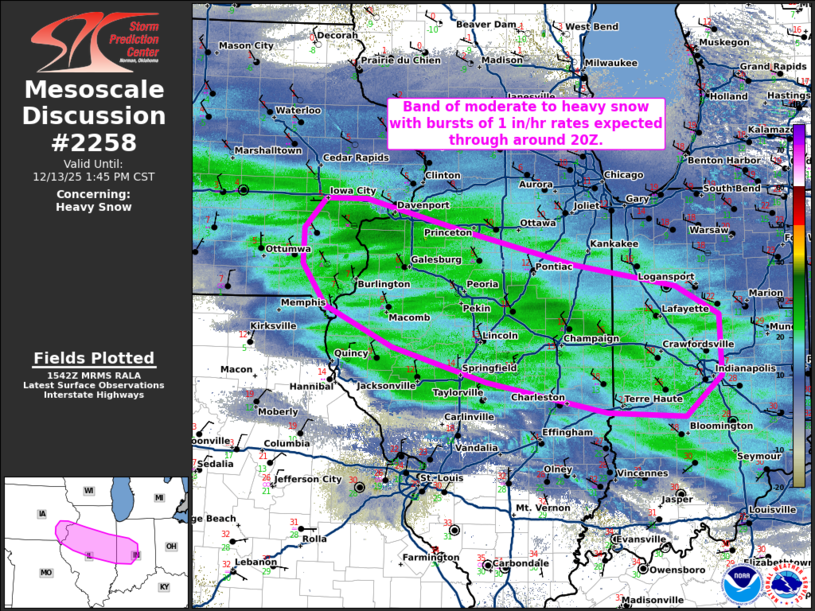
   Mesoscale Discussion 2258
   NWS Storm Prediction Center Norman OK
   0943 AM CST Sat Dec 13 2025

   Areas affected...far southeast IA...central IL...amd west-central IN

   Concerning...Heavy snow

   Valid 131543Z - 131945Z

   SUMMARY...A band of moderate to heavy snow with bursts of rates
   around 1 inch per hour expected through around 20Z.

   DISCUSSION...The latest mosaic radar data and surface observations
   depict a swath of moderate to locally heavy snow spreading eastward
   across eastern IA, central IL, and western IN. As strengthening DCVA
   preceding an embedded midlevel perturbation (evident in water-vapor
   imagery) continues spreading eastward into IL over the next couple
   hours, an uptick in the coverage of heavy snowfall rates can be
   expected. This increase should generally focus in an east/west
   corridor extending from southeast IA across central IL into
   west-central IN through around 20Z -- when the aforementioned lift
   overspreads a cold, deeply saturated profile with a favorable
   isothermal layer below 700 mb for aggregation. Snowfall rates of
   around 1 inch per hour are expected beneath the core of the heaviest
   banding, with bursts of locally higher rates possible.

   ..Weinman.. 12/13/2025

   ...Please see www.spc.noaa.gov for graphic product...

   ATTN...WFO...IWX...IND...LOT...ILX...DVN...

   LAT...LON   39398761 39728927 40099058 40519152 40969185 41349183
               41669154 41669096 41338964 40968807 40738664 40418605
               39778602 39338653 39398761
|
|
|
Top/All Mesoscale Discussions/Forecast Products/Home |
|