| Mesoscale Discussion 2234 | |
| < Previous MD | |
|
|
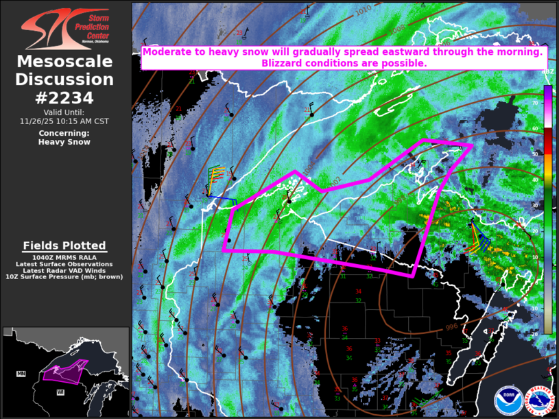
   Mesoscale Discussion 2234
   NWS Storm Prediction Center Norman OK
   0442 AM CST Wed Nov 26 2025

   Areas affected...Parts of northern WI into western Upper MI

   Concerning...Heavy snow

   Valid 261042Z - 261615Z

   SUMMARY...Moderate to heavy snow will gradually spread eastward
   through the morning. Blizzard conditions are possible.

   DISCUSSION...Moderate to locally heavy snow is ongoing at 10 UTC
   across parts of northern WI into far western Upper MI, to the
   west/northwest of a 993 mb surface low near the northeast
   WI/southern Upper MI border. This surface low and the accompanying
   midlevel low/trough are both forecast to strengthen as they move
   eastward today. As this occurs, continued strong ascent and
   low/midlevel cooling will allow for moderate to locally heavy snow
   to gradually spread eastward across parts of western Upper MI
   through the morning.

   Snow rates of near/above 1 inch per hour will be possible, with some
   potential enhancement from Lake Superior as cooler temperatures
   aloft overspread the region. In addition, strong northerly low-level
   flow (with 40-50 kt currently just above the surface from the KDLH
   VWP) will also spread eastward with time. This strong flow combined
   with increasing low-level cold advection will support strong gusts
   to near/above 40 mph, resulting in reduced visibility within the
   heavier snow bands and at least localized blizzard conditions.

   ..Dean.. 11/26/2025

   ...Please see www.spc.noaa.gov for graphic product...

   ATTN...WFO...MQT...GRB...DLH...

   LAT...LON   46169190 46679176 47149067 46919019 47048934 47528838
               47448750 47158788 46908810 45878860 45948912 46169103
               46169190
|
|
|
Top/All Mesoscale Discussions/Forecast Products/Home |
|