| Mesoscale Discussion 2232 | |
| < Previous MD | |
|
|
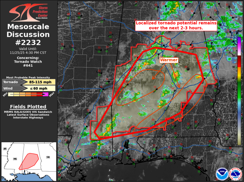
Mesoscale Discussion 2232 NWS Storm Prediction Center Norman OK 0236 PM CST Tue Nov 25 2025 Areas affected...Southeastern Mississippi into central Alabama Concerning...Tornado Watch 641... Valid 252036Z - 252230Z The severe weather threat for Tornado Watch 641 continues. SUMMARY...A brief tornado or two and isolated wind damage remain possible where surface heating/low-level lapse rates remain strongest this afternoon. A weakening trend can be expected with eventual loss of daytime heating. DISCUSSION...Overall trends for storms within WW 641 this afternoon have been for relatively brief intensification. A few cells have continued to show weak low-level rotation, but this has also been rather transient. Local VAD data suggest low-level shear has weakened slightly, but is still sufficient for brief tornado potential. This potential will be maximized where surface heating has been greatest: southwest of Birmingham and parts of southern/east-central Alabama. Storms should be able to maintain some intensity for the next 2-3 hours. Beyond that point, diminishing surface heating will lead to a weakening trend late this afternoon. ..Wendt.. 11/25/2025 ...Please see www.spc.noaa.gov for graphic product... ATTN...WFO...BMX...MOB...JAN... LAT...LON 30918882 31128901 32308825 33068771 33398744 33508704 33418632 33308567 32798550 32608544 31668621 31188732 30918882 MOST PROBABLE PEAK TORNADO INTENSITY...85-115 MPH MOST PROBABLE PEAK WIND GUST...UP TO 60 MPH |
|
|
Top/All Mesoscale Discussions/Forecast Products/Home |
|