| Mesoscale Discussion 2221 | |
| < Previous MD | |
|
|
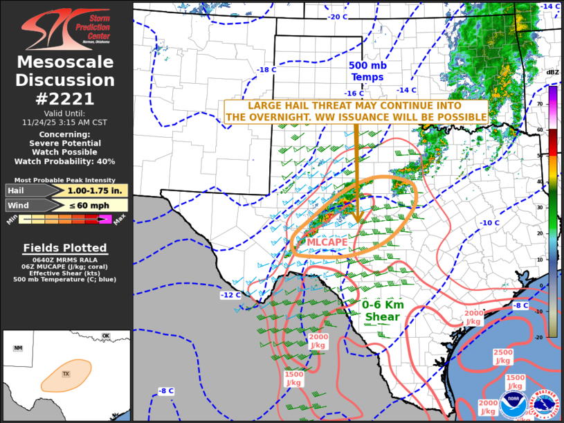
   Mesoscale Discussion 2221
   NWS Storm Prediction Center Norman OK
   1243 AM CST Mon Nov 24 2025

   Areas affected...West-central and Southwest Texas

   Concerning...Severe potential...Watch possible

   Valid 240643Z - 240915Z

   Probability of Watch Issuance...40 percent

   SUMMARY...An isolated large hail threat may continue into the
   overnight period across parts of west-central and southwest Texas.
   Weather watch issuance will be possible.

   DISCUSSION...The latest mosaic radar imagery shows several small
   thunderstorm clusters extending from north-central Texas
   southwestward toward the Big Bend. The strongest thunderstorms are
   located along a surface trough in southwest Texas along an axis of
   moisture and instability. Within this airmass, the RAP shows MLCAPE
   in the 1000 to 2000 J/kg range. Storm coverage is expected to
   continue as low-level flow and large-scale ascent both gradually
   increase. The latest WSR-88D VWP at San Angelo has 0-6 km shear near
   55 knots with some directional shear in the low to mid-levels. This
   environment may support rotation within the strongest storms, and
   isolated supercells with large hail will be possible. RAP forecast
   soundings at San Angelo have poor mid-level lapse rates suggesting
   any hail threat should be marginal overnight.

   ..Broyles/Hart.. 11/24/2025

   ...Please see www.spc.noaa.gov for graphic product...

   ATTN...WFO...FWD...SJT...MAF...

   LAT...LON   32100067 31330170 30840225 30410219 30320181 30310060
               30579960 30939896 31539840 31919822 32249828 32409848
               32559912 32499978 32100067

   MOST PROBABLE PEAK WIND GUST...UP TO 60 MPH
   MOST PROBABLE PEAK HAIL SIZE...1.00-1.75 IN
|
|
|
Top/All Mesoscale Discussions/Forecast Products/Home |
|