| Mesoscale Discussion 2219 | |
| < Previous MD | |

|
|
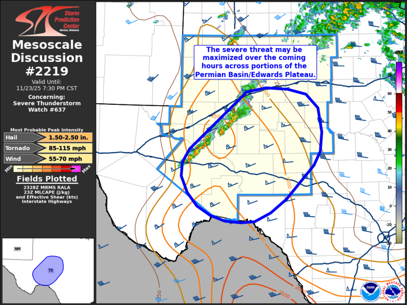
Mesoscale Discussion 2219 NWS Storm Prediction Center Norman OK 0530 PM CST Sun Nov 23 2025 Areas affected...Portions of the Permian Basin and the Edwards Plateau Concerning...Severe Thunderstorm Watch 637... Valid 232330Z - 240130Z The severe weather threat for Severe Thunderstorm Watch 637 continues. SUMMARY...Strong/severe thunderstorms remain probable in the coming hours across portions of the Permian Basin/Edwards Plateau where the convective environment remains very favorable for organized convection. DISCUSSION...Latest radar imagery from KMAF shows a broken line of thunderstorms between the I-20 and I-10 corridors west of the San Angelo, TX region. While most cells remain fairly weak, a leading supercell has shown periodic intensification and a persistent, albeit weak, mid-level mesocyclone. Despite the meager intensity thus far, these cells are beginning to move into the axis of better low-level moisture where MLCAPE is regionally maximized (between 1000-1500 J/kg). Regional VWPs continue to sample elongated hodographs featuring 0-6 km BWD values on the order of 50-60 knots. As such, the regionally best convective environment remains immediately downstream of ongoing cells, which may support an uptick in convective intensity in the coming hours. Additionally, new updraft development is noted in IR imagery on the southwestern flank of the broken band, hinting that an increase in thunderstorm coverage is probable. Recent CAM solutions support this idea and suggest thunderstorm coverage may be maximized in the coming hours. ..Moore.. 11/23/2025 ...Please see www.spc.noaa.gov for graphic product... ATTN...WFO...EWX...SJT...MAF... LAT...LON 29870237 30050267 30310288 30630303 30900301 31170284 32090178 32290156 32370112 32340062 32240020 31979993 31499984 31119989 30850004 30200066 29930102 29750137 29730168 29760203 29870237 MOST PROBABLE PEAK TORNADO INTENSITY...85-115 MPH MOST PROBABLE PEAK WIND GUST...55-70 MPH MOST PROBABLE PEAK HAIL SIZE...1.50-2.50 IN |
|
|
Top/All Mesoscale Discussions/Forecast Products/Home |
|