| Mesoscale Discussion 2213 | |
| < Previous MD | |
|
|
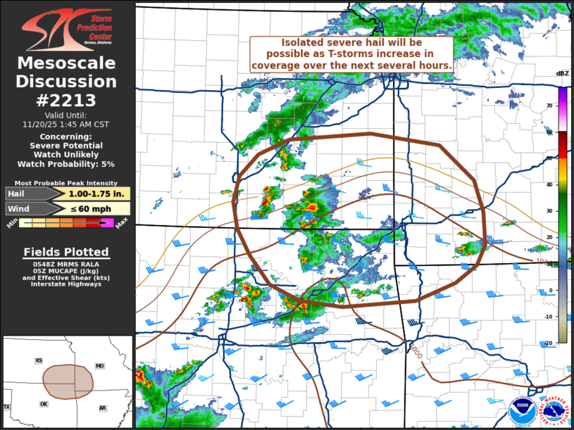
   Mesoscale Discussion 2213
   NWS Storm Prediction Center Norman OK
   1151 PM CST Wed Nov 19 2025

   Areas affected...Southeast Kansas into northeast
   Oklahoma...southwest Missouri and far northwest Arkansas

   Concerning...Severe potential...Watch unlikely

   Valid 200551Z - 200745Z

   Probability of Watch Issuance...5 percent

   SUMMARY...Thunderstorms are expected to increase in coverage over
   the next several hours across northeast Oklahoma, southeast Kansas
   and into southwest Missouri and northwest Arkansas. While buoyancy
   is fairly limited, strong shear may compensate and support a few
   strong/severe storms.

   DISCUSSION...Latest regional radar mosaics show an uptick in
   convection across the KS/OK/MO/AR region over the past hour. This
   comes as isentropic ascent within a diffuse warm frontal zone
   increases in tandem with a strengthening of 925-850 mb winds noted
   in upstream VWPs. The warming/moistening in this layer is also
   supporting a northward expansion of MUCAPE, and while buoyancy
   profiles remain fairly marginal per recent forecast soundings, this
   environment has been sufficient for deep convection. Regional VWPs
   and mesoanalyses continue to show 40-50 knot deep-layer wind shear
   across the region with favorable hodographs for splitting
   supercells. The expectation is for transient supercells to emerge
   and periodically pose a threat for large hail (most likely between 1
   to 1.75 inches in diameter). Storm interactions and motions along
   the frontal zone should promote upscale growth into clusters, which
   should limit the coverage/longevity of the hail threat. As such,
   watch issuance is not expected.

   ..Moore/Smith.. 11/20/2025

   ...Please see www.spc.noaa.gov for graphic product...

   ATTN...WFO...LZK...SGF...EAX...TSA...TOP...ICT...OUN...

   LAT...LON   36239673 36639709 36989730 37369738 37719729 38029696
               38239644 38319501 38149382 37659322 37219307 36769306
               36489320 36249358 36019425 35939549 36019622 36239673

   MOST PROBABLE PEAK WIND GUST...UP TO 60 MPH
   MOST PROBABLE PEAK HAIL SIZE...1.00-1.75 IN
|
|
|
Top/All Mesoscale Discussions/Forecast Products/Home |
|