| Mesoscale Discussion 2210 | |
| < Previous MD | |
|
|
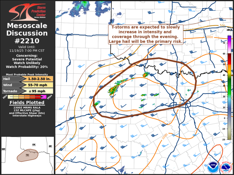
   Mesoscale Discussion 2210
   NWS Storm Prediction Center Norman OK
   0503 PM CST Wed Nov 19 2025

   Areas affected...Northwest Texas into far southern Oklahoma

   Concerning...Severe potential...Watch unlikely

   Valid 192303Z - 200100Z

   Probability of Watch Issuance...20 percent

   SUMMARY...Thunderstorms are expected to gradually increase in
   intensity and coverage through the evening hours. Isolated to
   scattered severe thunderstorms are possible, and will mainly pose a
   large hail threat.

   DISCUSSION...GOES imagery over the past 40 minutes reveals a pair of
   deeper convective updrafts along/north of the I-20 corridor with
   shallower/weaker cells closer to the DFW metro area. This comes as
   ascent ahead of a large-scale upper wave gradually overspreads the
   region where capping has become very weak/negligible owing to warm
   surface temperatures in the upper 70s and low 80s. Broad-scale
   ascent will continue to increase through the evening as the wave
   shifts east, resulting in a gradual increase in thunderstorm
   coverage through the evening across northern TX into the Red River
   Valley. Modest mid-level lapse rates will likely favor a slow uptick
   in convective intensity, but strong mid/high-level flow will provide
   adequate deep-layer shear for organized convection, including the
   potential for splitting supercells once storms become sufficiently
   deep. Given weak flow in the lowest few kilometers (per regional
   VWPs) the primary risk should be large hail (most likely 1 to 2
   inches), though sporadic severe winds are also possible. It remains
   somewhat unclear how many intense storms will emerge across northern
   TX/southern OK due to the potential for destructive storm
   interactions/upscale growth; however, this region may be the
   relatively best corridor for severe storms over the next few hours.
   Watch issuance is not imminent, but trends will be monitored.

   ..Moore/Smith.. 11/19/2025

   ...Please see www.spc.noaa.gov for graphic product...

   ATTN...WFO...FWD...OUN...SJT...LUB...MAF...

   LAT...LON   32320015 32340030 32460048 32710066 33020066 33280042
               34219901 34369860 34389833 34429791 34249694 34129672
               33899646 33599636 33299640 33019658 32769690 32649732
               32259977 32320015

   MOST PROBABLE PEAK TORNADO INTENSITY...UP TO 95 MPH
   MOST PROBABLE PEAK WIND GUST...55-70 MPH
   MOST PROBABLE PEAK HAIL SIZE...1.50-2.50 IN
|
|
|
Top/All Mesoscale Discussions/Forecast Products/Home |
|