| Mesoscale Discussion 2207 | |
| < Previous MD | |

|
|
   Mesoscale Discussion 2207
   NWS Storm Prediction Center Norman OK
   1155 PM CST Mon Nov 17 2025

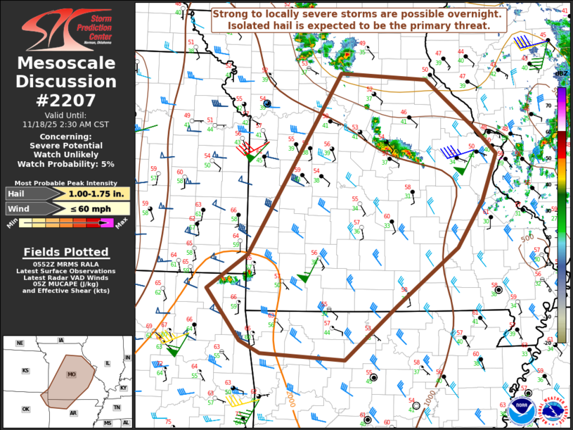
   Areas affected...Parts of MO into far northeast OK/northwest AR

   Concerning...Severe potential...Watch unlikely

   Valid 180555Z - 180830Z

   Probability of Watch Issuance...5 percent

   SUMMARY...Strong to locally severe storms are possible overnight.
   Isolated hail is expected to be the primary threat.

   DISCUSSION...A compact mid/upper-level low is moving eastward across
   NE late this evening. Southeast of this low, a strong (40+ kt)
   southwesterly low-level jet is currently being sampled by area VWPs.
   The warm-advection regime associated with this low-level jet will
   support additional rounds of elevated convection overnight from the
   Ozarks into the mid MS Valley.

   The most favorable environment for organized storms overnight will
   extend from northeast OK/northwest AR into central/southern MO,
   where a plume of moderate MUCAPE (1000-2000 J/kg) will overlap
   favorable effective shear (greater than 40+ kt). While this
   environment would conditionally support elevated supercells, the
   strongest large-scale ascent may tend to remain displaced to the
   north and east, in closer proximity to the left-exit region of a
   jetlet associated with the mid/upper-level low. This results in some
   uncertainty regarding the intensity and organization of overnight
   elevated convection with southward extent.

   Generally modest midlevel lapse rates may temper hail potential to
   some extent, but isolated severe hail could accompany the strongest
   overnight storms. Locally gusty winds also cannot be ruled out,
   especially if any sustained/organized cells or clusters can develop
   with time.

   ..Dean/Hart.. 11/18/2025

   ...Please see www.spc.noaa.gov for graphic product...

   ATTN...WFO...LSX...LZK...SGF...EAX...TSA...

   LAT...LON   36799528 37269458 39759300 39669151 38959062 38639030
               38009055 37369099 36569204 35839292 35929436 36099471
               36799528

   MOST PROBABLE PEAK WIND GUST...UP TO 60 MPH
   MOST PROBABLE PEAK HAIL SIZE...1.00-1.75 IN
|
|
|
Top/All Mesoscale Discussions/Forecast Products/Home |
|