|
|
| Mesoscale Discussion 2202 | |
|
|
Mesoscale Discussion 2202
NWS Storm Prediction Center Norman OK
0955 PM CST Sun Nov 09 2025
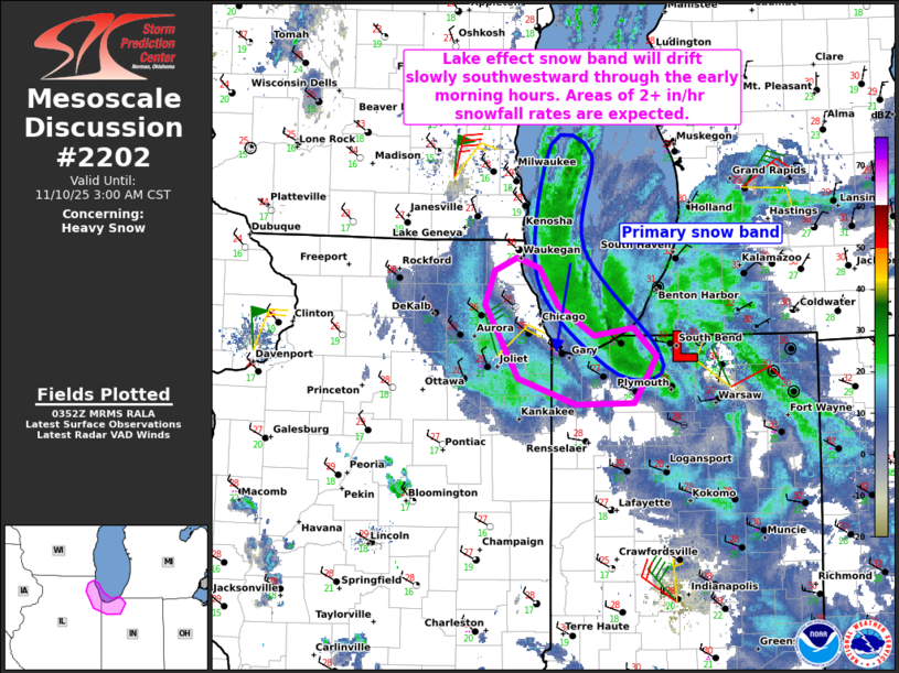
Areas affected...Northwestern Indiana and northeastern Illinois
Concerning...Heavy snow
Valid 100355Z - 100900Z
SUMMARY...An intense lake effect snow band will drift slowly
south-southwestward across northwestern Indiana and northeastern
Illinois through the early morning hours. Heavy snowfall rates of 2+
inches/hour are expected under the core of the band.
DISCUSSION...Regional radar data shows a well-defined snowband
favorably oriented along the long axis of Lake MI. This snowband is
on the backside of a mesoscale low that evolved off of Lake MI and
is moving slowly southward across far northern IN. As this feature
continues southward, and low-level flow continues veering to a
north-northeast direction over Lake MI, the band will have a
tendency to drift gradually south-southwestward across far
northwestern IN and northeastern IL through the early morning hours.
The 00Z GRB sounding sampled very cold temperatures aloft (-40C at
500 mb), which is yielding steep low/midlevel lapse rates and a deep
convective boundary layer (aided by relatively warm lake waters).
Given the favorable/persistent orientation of low-level flow down
Lake MI and significant convective enhancement, heavy snowfall rates
of 2-3 inches per hour are expected under the core of the band as it
continues south-southwestward. Isolated lightning flashes will also
be possible. There will likely be a sharp drop-off in the heaviest
snowfall rates as the band tracks southwestward across northeastern
IL (owing to less favorable thermodynamic conditions), though
exactly where this will occur is uncertain. Additionally, gusty
winds within the band will yield significant visibility reductions
where snowfall rates are maximized.
..Weinman.. 11/10/2025
...Please see www.spc.noaa.gov for graphic product...
ATTN...WFO...IWX...LOT...
LAT...LON 42278765 41998745 41768708 41818669 41608645 41248667
41228727 41438787 42008820 42268810 42358788 42278765
|
|
|
Top/All Mesoscale Discussions/Forecast Products/Home |
|