|
|
| Mesoscale Discussion 2192 | |

|
|
   Mesoscale Discussion 2192
   NWS Storm Prediction Center Norman OK
   0249 PM CDT Tue Oct 28 2025

   Areas affected...east Texas and west Louisiana

   Concerning...Severe potential...Watch possible

   Valid 281949Z - 282145Z

   Probability of Watch Issuance...60 percent

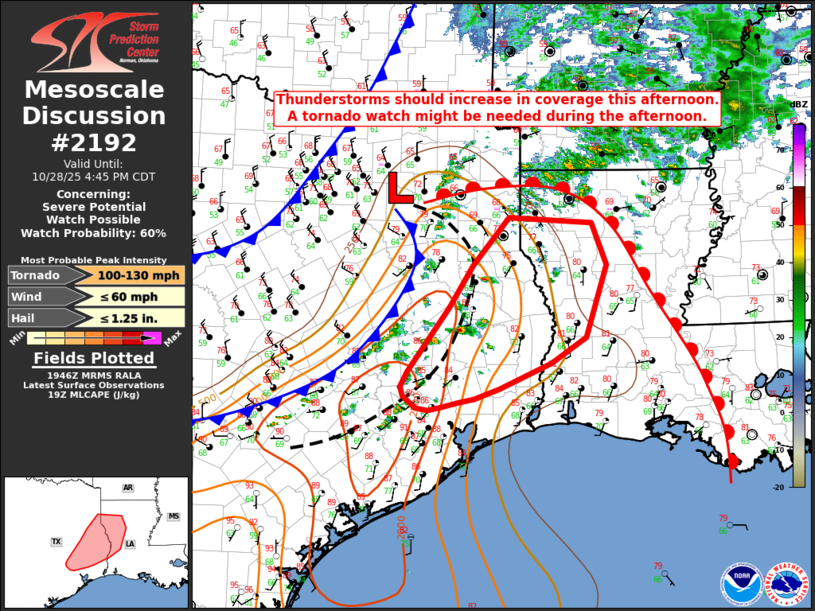
   SUMMARY...Thunderstorms developing across east Texas should increase
   in coverage and intensity. Some tornado potential will exist with
   any sustained supercell thunderstorm this afternoon across the
   region. Conditions will be monitored for issuance of a tornado
   watch.

   DISCUSSION...A cold front with a preceding wind shift is moving east
   across east Texas this afternoon. Ahead of this wind shift, surface
   temperatures have warmed into the upper 70Fs and low 80Fs, with
   upper 60Fs dewpoints. As midlevel lapse rates modestly steepen
   through peak heating, mixed-layer CAPE values up to 2000 J/kg should
   develop across east Texas and far west Louisiana. Large-scale
   kinematic fields are also quite strong, with effective-layer shear
   on the order of 50-65 knots across the area.

   Showers and thunderstorms presently developing along the
   aforementioned wind shift should deepen and increase in coverage as
   they encounter the increasing instability. Given the forecast degree
   of instability and the overall deep-layer shear profile, supercells
   will be possible with any discrete storms. With time, increasing
   forced ascent from the eastward moving cold front should promote
   upscale growth into one or more linear segments.

   Low-level wind fields are expected to strengthen slightly this
   afternoon and evening ahead of the surface front, supporting
   effective-layer storm-relative helicity on the order of 100-200
   m2/s2 for any supercell moving slightly south of east. Forecast
   soundings indicate that with time, continued moistening of the
   boundary layer will eventually lead to nearly saturated low-level
   profiles and extremely low LCLs. With ESRH on the order of 200 m2/s2
   and very low LCLs, supercells (both isolated and in a line) as well
   as any linear segments will have the potential to produce tornadoes.


   Trends will be monitored this afternoon for indication of sustained,
   robust convection ahead of the surface front. If/when this occurs, a
   tornado threat may evolve and a tornado watch would likely be
   warranted. Convective trends will continue to be monitored.

   ..Marsh/Barnes/Bunting.. 10/28/2025

   ...Please see www.spc.noaa.gov for graphic product...

   ATTN...WFO...LCH...SHV...HGX...

   LAT...LON   30079471 30039497 29969522 29929540 29959559 30119577
               30239581 30429571 30649555 31249510 31799474 32419421
               32339297 31809275 30879305 30539358 30219434 30079471

   MOST PROBABLE PEAK TORNADO INTENSITY...100-130 MPH
   MOST PROBABLE PEAK WIND GUST...UP TO 60 MPH
   MOST PROBABLE PEAK HAIL SIZE...UP TO 1.25 IN
|
|
|
Top/All Mesoscale Discussions/Forecast Products/Home |
|