|
|
| Mesoscale Discussion 2187 | |

|
|
   Mesoscale Discussion 2187
   NWS Storm Prediction Center Norman OK
   0106 AM CDT Mon Oct 27 2025

   Areas affected...Parts of the western Florida Panhandle

   Concerning...Severe potential...Watch unlikely

   Valid 270606Z - 270830Z

   Probability of Watch Issuance...20 percent

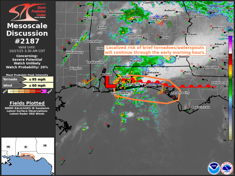
   SUMMARY...A localized risk of brief tornadoes/waterpsouts will
   continue through the early morning hours while spreading eastward
   across the western Florida Panhandle. Given the localized and and
   conditional nature of the risk, a watch is not expected.

   DISCUSSION...The latest surface analysis shows a mesoscale
   low/frontal wave over the far western FL Panhandle. A marine front
   extends eastward across the remainder of the southern FL Panhandle
   -- demarcating the northern bound of upper 60s to lower 70s
   boundary-layer dewpoints. Ahead of the frontal wave, the EVX VWP is
   sampling 35-kt east-southeasterly flow at 0.5 km AGL, which is
   yielding a clockwise-curved low-level hodograph (150-180 m2/s2 0-500
   m SRH per EVX). As the frontal wave tracks eastward along the marine
   front, a forced confluence zone/low-level warm-advection plume will
   continue supporting thunderstorm development across the FL Panhandle
   through the early morning hours. Given the implied enhanced
   low-level streamwise vorticity and relatively moist boundary layer,
   transient supercell structures will continue to pose a risk of brief
   tornadoes/waterspouts. However, poor lapse rates and a very narrow
   zone of surface-based effective-inflow-layer air should keep the
   overall threat localized and conditional -- precluding the need for
   a watch.

   ..Weinman/Smith.. 10/27/2025

   ...Please see www.spc.noaa.gov for graphic product...

   ATTN...WFO...TAE...MOB...

   LAT...LON   30128757 30548760 30668740 30748698 30708644 30588571
               30298534 30008541 29908579 30018684 30128757

   MOST PROBABLE PEAK TORNADO INTENSITY...UP TO 95 MPH
   MOST PROBABLE PEAK WIND GUST...UP TO 60 MPH
|
|
|
Top/All Mesoscale Discussions/Forecast Products/Home |
|