|
|
| Mesoscale Discussion 2184 | |
|
|
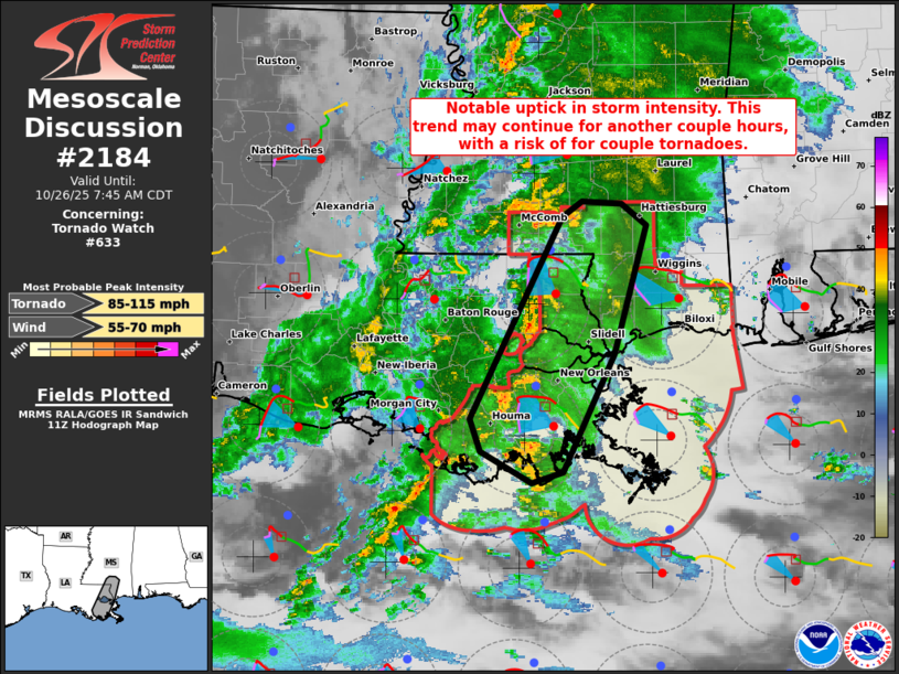
Mesoscale Discussion 2184 NWS Storm Prediction Center Norman OK 0617 AM CDT Sun Oct 26 2025 Areas affected...Parts of southeastern Louisiana and southern Mississippi Concerning...Tornado Watch 633... Valid 261117Z - 261245Z The severe weather threat for Tornado Watch 633 continues. SUMMARY...A notable uptick in thunderstorm intensity is evident across parts of southeastern Louisiana into southern Mississippi -- within Tornado Watch 633. This trend may continue for at least another couple hours, with a risk for a couple tornadoes. DISCUSSION...The latest radar and lightning data indicate an increase in thunderstorm intensity/organization over the last hour -- generally in a north-south corridor extending from southeast LA into southern MS. A couple radar-confirmed tornadoes have been noted with this activity. The broken band of supercells are evolving east-northeastward in an environment characterized by enlarged/clockwise-curved low-level hodographs (upwards of 250 m2/s2 0-1 km SRH per VWP) and lower 70s boundary-layer dewpoints. As these established storms and favorable environment continue spreading eastward this morning, the risk for couple tornadoes will continue across Tornado Watch 633. ..Weinman.. 10/26/2025 ...Please see www.spc.noaa.gov for graphic product... ATTN...WFO...MOB...JAN...LIX... LAT...LON 29629090 31309002 31438983 31428945 31238921 30178952 29199002 29109032 29359081 29629090 MOST PROBABLE PEAK TORNADO INTENSITY...85-115 MPH MOST PROBABLE PEAK WIND GUST...55-70 MPH |
|
|
Top/All Mesoscale Discussions/Forecast Products/Home |
|