|
|
| Mesoscale Discussion 2166 | |
|
|
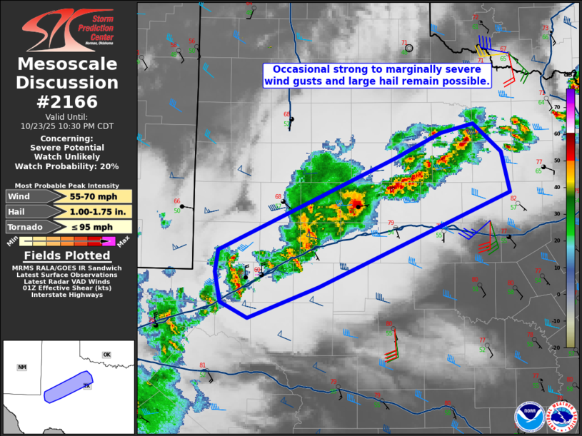
   Mesoscale Discussion 2166
   NWS Storm Prediction Center Norman OK
   0835 PM CDT Thu Oct 23 2025

   Areas affected...Permian Basin into Rolling Plains

   Concerning...Severe potential...Watch unlikely

   Valid 240135Z - 240330Z

   Probability of Watch Issuance...20 percent

   SUMMARY...Isolated large hail and marginally severe winds could
   occur through about midnight.

   DISCUSSION...The most intense storms have generally trended downward
   in the vicinity of Midland. KMAF radar imagery shows outflow
   beginning to push away from this activity as well. Farther
   northeast, low-level moisture is greater and storms have maintained
   some intensity. Despite the onset of nocturnal cooling and
   increasing MLCIN, the increase in the low-level jet noted on
   regional VADs as well as modestly increasing mid-level ascent
   suggests some activity will persist perhaps to around midnight local
   time. Large hail will be possible with newer updrafts given the
   moderate shear and mid-level lapse rates at or above 7 C/km (from
   evening observed soundings). However, cores will likely collapse
   quickly. Isolated strong to marginally severe winds are also
   possible.

   ..Wendt/Hart.. 10/24/2025

   ...Please see www.spc.noaa.gov for graphic product...

   ATTN...WFO...FWD...OUN...SJT...LUB...MAF...

   LAT...LON   31650271 31970278 32210274 33230046 33499987 33599945
               33299909 32859899 31810144 31470235 31650271

   MOST PROBABLE PEAK TORNADO INTENSITY...UP TO 95 MPH
   MOST PROBABLE PEAK WIND GUST...55-70 MPH
   MOST PROBABLE PEAK HAIL SIZE...1.00-1.75 IN
|
|
|
Top/All Mesoscale Discussions/Forecast Products/Home |
|