|
|
| Mesoscale Discussion 2144 | |
|
|
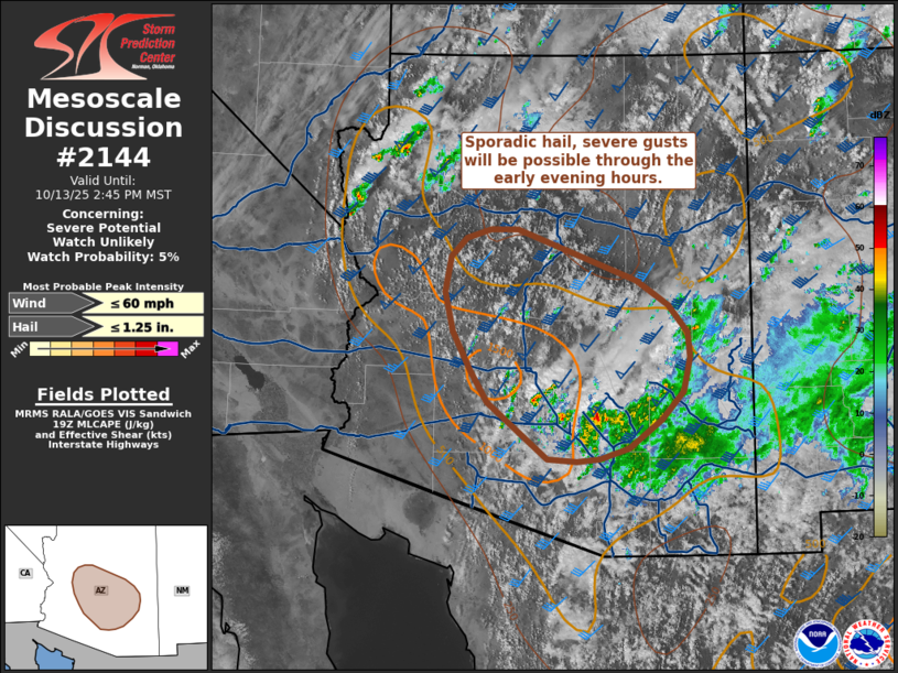
   Mesoscale Discussion 2144
   NWS Storm Prediction Center Norman OK
   0241 PM CDT Mon Oct 13 2025

   Areas affected...Central Arizona

   Concerning...Severe potential...Watch unlikely

   Valid 131941Z - 132145Z

   Probability of Watch Issuance...5 percent

   SUMMARY...Thunderstorms are expected to increase in coverage through
   the evening hours. Sporadic hail and severe gusts appear possible.

   DISCUSSION...Over the past hour, convective intensity has increased
   slightly per GOES IR imagery and lightning trends. This comes as
   temperatures on the western periphery of a more expansive cloud
   shield continue to warm into the upper 70s and low 80s, which is
   supporting MLCAPE values upwards of 500-1000 J/kg. The KIWA VWP
   continues to sample elongated/straight hodographs with 0-6 km BWD
   values on the order of 50 knots. A recent cell split over
   south-central AZ provides further evidence of this favorable
   kinematic environment. The combination of continued daytime heating,
   very weak capping, and orographic ascent should promote an increase
   in thunderstorm coverage through the late afternoon and evening
   hours. Despite the strong wind shear, modest mid-level lapse rates
   and meager forcing for ascent (mainly associated with gradual height
   falls ahead of an approaching upper wave) will likely promote
   somewhat anemic thunderstorms that exhibit periods of
   intensification to near severe limits as they sufficiently deepen to
   realize the full kinematic profile. While a few instances of severe
   gusts and large hail appear possible - particularly during the 20-00
   UTC period - confidence in a widespread/prolonged severe threat
   remains limited.

   ..Moore/Hart.. 10/13/2025

   ...Please see www.spc.noaa.gov for graphic product...

   ATTN...WFO...TWC...FGZ...PSR...

   LAT...LON   35021221 34441061 34171018 33860991 33580988 33180998
               32861027 32541071 32421111 32401142 32421181 33071263
               33431286 33861310 34321321 34711313 34921292 35021259
               35021221

   MOST PROBABLE PEAK WIND GUST...UP TO 60 MPH
   MOST PROBABLE PEAK HAIL SIZE...UP TO 1.25 IN
|
|
|
Top/All Mesoscale Discussions/Forecast Products/Home |
|