|
|
| Mesoscale Discussion 2141 | |

|
|
   Mesoscale Discussion 2141
   NWS Storm Prediction Center Norman OK
   0401 PM CDT Fri Oct 10 2025

   Areas affected...parts of southern Nevada and adjacent portions of
   southeastern California and southwestern Utah

   Concerning...Severe potential...Watch unlikely

   Valid 102101Z - 102300Z

   Probability of Watch Issuance...5 percent

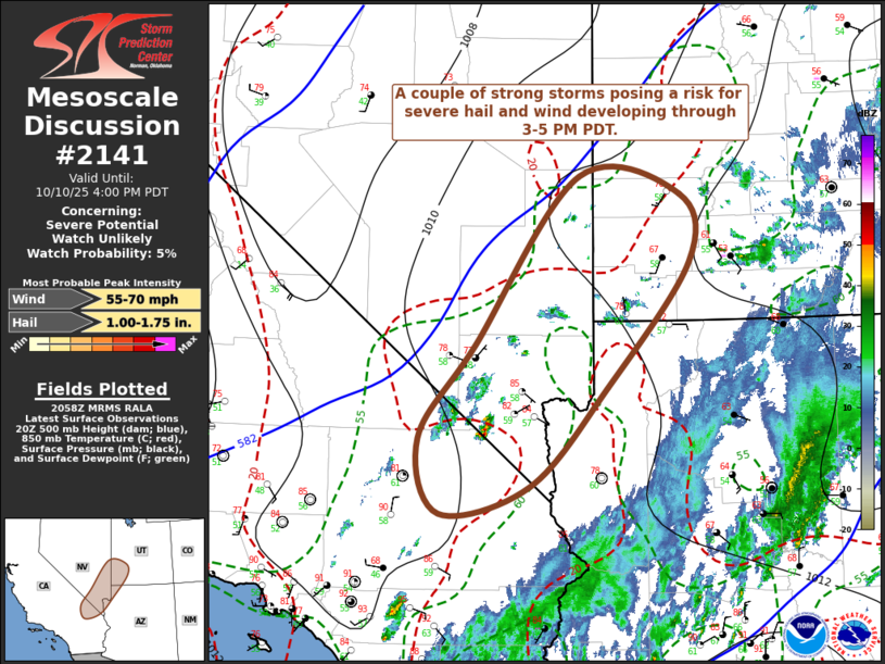
   SUMMARY...A couple of sustained strong thunderstorms may develop
   through 3-5 PM PDT, accompanied by a risk for severe hail and wind.

   DISCUSSION...Downstream of a still broad, deep mid-level low
   centered offshore of the Oregon coast, moistening on southerly
   low-level flow across the lower Colorado Valley into Mohave Desert
   is contributing to modest boundary-layer destabilization with
   insolation, beneath a residual pocket of cooler mid-level
   temperatures.  This is occurring in the presence of strong
   deep-layer shear, beneath a belt of 50-60 kt flow around 300 mb
   focused across southern Nevada and adjacent portions of southeastern
   California and southwestern Utah.

   Latest objective analysis and forecast soundings indicate the
   presence of lingering mid-level inhibition, but this is eroding and
   will continue to do so with additional boundary-layer warming and
   perhaps increasing large-scale forcing for ascent.  Showers have
   begun to develop, with lightning already evident with one cell near
   the California/Nevada border to the southwest of Las Vegas.  Further
   intensification seems probable during the next few hours, leading to
   sustained scattered thunderstorm development.

   Embedded within an environment characterized by southwesterly 30 kt
   deep-layer mean flow, stronger storms with evolving supercell
   structures will tend to propagate eastward/southeastward into early
   evening accompanied by at least some risk for severe hail and
   localized potentially damaging wind gusts.

   ..Kerr/Guyer.. 10/10/2025

   ...Please see www.spc.noaa.gov for graphic product...

   ATTN...WFO...SLC...VEF...

   LAT...LON   35701644 36721567 38601423 38391284 37641272 36251386
               35171491 34861614 35701644

   MOST PROBABLE PEAK WIND GUST...55-70 MPH
   MOST PROBABLE PEAK HAIL SIZE...1.00-1.75 IN
|
|
|
Top/All Mesoscale Discussions/Forecast Products/Home |
|