| Mesoscale Discussion 21 | |
| < Previous MD | |
|
|
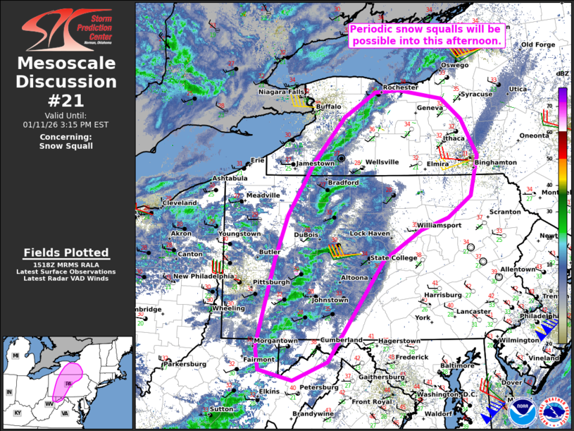
   Mesoscale Discussion 0021
   NWS Storm Prediction Center Norman OK
   0919 AM CST Sun Jan 11 2026

   Areas affected...Parts of southwestern/south-central
   NY...western/central PA...and far northern WV and western MD

   Concerning...Snow Squall

   Valid 111519Z - 112015Z

   SUMMARY...Periodic snow squalls with bursts of heavy snow and
   visibility reductions to 1/4 to 1/2 mile will be possible into this
   afternoon.

   DISCUSSION...Preceding a robust midlevel trough and within the
   left-exit region of a 90-100-kt midlevel jet, a secondary cold front
   is tracking eastward across parts of western NY, western PA, and far
   northern WV. Mosaic radar data indicates a few loosely organized
   snow squalls along the wind shift -- some of which have been
   associated with visibility reductions to 1/4 mile and gusty winds.
   Through the afternoon, cold midlevel temperatures accompanying the
   trough will steepen low-level lapse rates (generating weak low-level
   instability) amid 30-40 kt of unidirectional west-southwesterly flow
   in the lowest 2 km (per regional VWP). This will support the
   development of periodic snow-squall conditions spreading eastward
   into the afternoon.

   Given the lack of a stronger cold front/low-level frontogenesis,
   these squalls may tend to be transient and generally be associated
   with visibility reductions of 1/2. However, 1/4 mile visibility and
   strong gusts will be possible with the stronger squalls that evolve,
   as seen by the Delevan NY State mesonet web cam in northeast
   Cattaraugus County NY at 1500-1515Z.

   ..Weinman.. 01/11/2026

   ...Please see www.spc.noaa.gov for graphic product...

   ATTN...WFO...BGM...BUF...CTP...LWX...PBZ...

   LAT...LON   40847957 41447933 42217883 42807830 43147773 43177729
               43067649 42787614 42277584 41707596 41407639 41237689
               40837756 39407859 39147924 39297985 39627990 40847957
|
|
|
Top/All Mesoscale Discussions/Forecast Products/Home |
|