| Mesoscale Discussion 18 | |
| < Previous MD | |

|
|
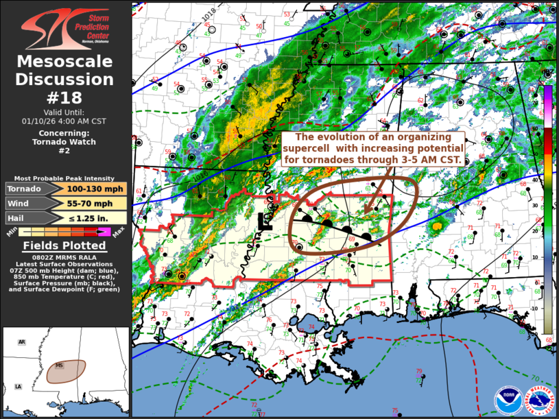
Mesoscale Discussion 0018 NWS Storm Prediction Center Norman OK 0204 AM CST Sat Jan 10 2026 Areas affected...parts of south central Mississippi and adjacent portions of western Alabama Concerning...Tornado Watch 2... Valid 100804Z - 101000Z The severe weather threat for Tornado Watch 2 continues. SUMMARY...The evolution of a supercell or two with increasing potential for tornadoes, perhaps a strong one, east of Jackson toward the Meridian MS vicinity through 3-5 AM CST. A new tornado will probably be needed within the next hour or two. DISCUSSION...There has been at least some recent increase in thunderstorm development within the moist warm sector, near/north of the McComb vicinity, where surface dew points near 70F appear to be supporting moderate boundary-layer based CAPE as high as 1500 J/kg. This appears to be occurring as a weak surface low migrates eastward into west central Mississippi near Jackson. During the next few hours, models suggest that strengthening southwesterly flow around the 850 mb level (to around 40 kt) may contribute to enlarging low-level hodographs along a remnant surface baroclinic zone southeast of Jackson into areas near/south of Meridian, coincident with boundary-layer destabilization associated with a slow northward advection of the warmer and more moist warm sector air. It appears this environment could become conducive to substantive further thunderstorm intensification and organization, including the evolution of a supercell or two accompanied by increasing potential for tornadoes, perhaps a strong one. ..Kerr.. 01/10/2026 ...Please see www.spc.noaa.gov for graphic product... ATTN...WFO...BMX...MOB...JAN... LAT...LON 32629018 32848928 32828793 32138807 31638894 31519040 32089058 32629018 MOST PROBABLE PEAK TORNADO INTENSITY...100-130 MPH MOST PROBABLE PEAK WIND GUST...55-70 MPH MOST PROBABLE PEAK HAIL SIZE...UP TO 1.25 IN |
|
|
Top/All Mesoscale Discussions/Forecast Products/Home |
|