| Mesoscale Discussion 17 | |
| < Previous MD | |
|
|
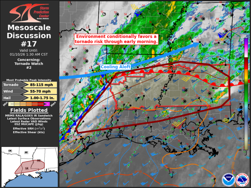
Mesoscale Discussion 0017 NWS Storm Prediction Center Norman OK 1107 PM CST Fri Jan 09 2026 Areas affected...far eastern Texas across Louisiana and into central Mississippi Concerning...Tornado Watch 2... Valid 100507Z - 100730Z The severe weather threat for Tornado Watch 2 continues. SUMMARY...Strong to severe storms remain possible tonight in and close to the watch area. Locally damaging wind and a tornado or two cannot be ruled out through Saturday morning. DISCUSSION...Surface analysis shows low pressure over northwest LA, with a cold front draped across far eastern TX. A warm front extends across northern LA and into central MS, with a very moist air mass across the warm sector. Lower 70s F dewpoints exist across much of southern LA and southeast TX, and this air mass should continue to gradually spread north. Currently, the strongest cells are along or even behind the cold front in TX, although isolated cells also exist along and north of the warm front. Recent convective trends suggest the activity approaching the Sabine Valley may become a bit better organized over the next few hours as cooling aloft gradually shifts east. In addition, southerly low-level winds ahead of this line and secondary pressure fall time after 09Z may yield a increased chance of isolated supercells across LA/MS well ahead of the cold front. Any isolated cells will have tornado potential as 0-1 SRH remains in excess of 100 to 150 m2/s2. ..Jewell.. 01/10/2026 ...Please see www.spc.noaa.gov for graphic product... ATTN...WFO...MOB...JAN...LIX...LCH...SHV...HGX... LAT...LON 30958882 30419160 29909522 30069531 30409512 31869384 32249357 32719062 32598932 32088841 31238843 30958882 MOST PROBABLE PEAK TORNADO INTENSITY...85-115 MPH MOST PROBABLE PEAK WIND GUST...55-70 MPH MOST PROBABLE PEAK HAIL SIZE...1.00-1.75 IN |
|
|
Top/All Mesoscale Discussions/Forecast Products/Home |
|