|
|
| Mesoscale Discussion 105 | |
|
|
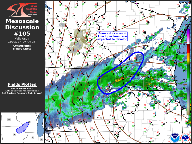
   Mesoscale Discussion 0105
   NWS Storm Prediction Center Norman OK
   1100 PM CST Thu Feb 19 2026

   Areas affected...Northeast Iowa...extreme southeast Minnesota...and
   southwest Wisconsin

   Concerning...Heavy snow

   Valid 200500Z - 201000Z

   SUMMARY...Heavy snow will develop/spread across northeast Iowa into
   southwest Wisconsin over the next several hours. Snow rates may
   exceed 1 inch per hour at times.

   DISCUSSION...Southwest-northeast oriented band of moderate-heavy
   snow persists across IA late this evening. This band is expected to
   spread/develop across northeast IA into southwest WI as the 700mb
   low advances across eastern IA into southern WI by 12z. Latest
   radar/satellite imagery suggest multiple heavier bands will begin to
   coalesce along an axis from near ALO-PDC-VOK as the primary midlevel
   circulation shifts east over the next few hours. While heavy snow
   with rates around 1 inch per hour are expected, a very narrow zone
   of mixed precipitation may exist along the eastern fringe of this
   corridor briefly before transitioning to snow.

   ..Darrow.. 02/20/2026

   ...Please see www.spc.noaa.gov for graphic product...

   ATTN...WFO...GRB...MKX...DVN...ARX...DMX...

   LAT...LON   43019271 43669143 44269029 43998980 42889077 42349218
               43019271
|
|
|
Top/All Mesoscale Discussions/Forecast Products/Home |
|